In this notebook, we demonstrate searching for and accessing ICESat-2 data using the Python earthaccess package, and reading and visualizing the data using xarray and pandas. We also use matplotlib and cartopy to produce a map of search results.
earthaccess is a community developed open source Python package to streamline programmatic search and access for NASA data archives. Users can find data sets and data granules, and either download or “stream” NASA data in as little as three “lines of code”, regardless of whether users are working in the cloud or on a local machine. The earthaccess package handles authentication for NASA Earthdata Login and the AWS hosted NASA Earthdata cloud. All you need is an Earthdata Login.
xarray has become the go to Python package for Earth Data Science. With v2024.10.0, xarray can be used to read and work with data stored hiearchical file structures like the HDF5 file format used for ICESat-2, using the DataTree structure. We use xarray.DataTree to read and explore ICESat-2 files.
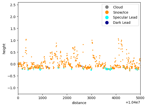
Although xarray could be used to work with the ICESat-2 data, the nested-group structure can be a little cumbersome. So we create a pandas.DataFrame object for a subset of data to make plotting easier.
Import libraries
As with all Python, we import the libraries we will use.
# Search for dataimport earthaccess# Read and work with dataimport xarray as xrimport pandas as pd# To plot resultsimport matplotlib.pyplot as pltfrom matplotlib.colors import ListedColormap, BoundaryNormfrom matplotlib.lines import Line2D# To plot map of resultsimport cartopyimport cartopy.crs as ccrsimport cartopy.feature as cfeature# Check package versions: you may want to update if you have older versions# See README.mdprint(f"earthaccess: {earthaccess.__version__}")print(f"xarray: {xr.__version__}")print(f"cartopy: {cartopy.__version__}")
/Users/mibe9765/miniforge3/envs/nsidc-tutorial-icesat2-apps/lib/python3.12/site-packages/tqdm/auto.py:21: TqdmWarning: IProgress not found. Please update jupyter and ipywidgets. See https://ipywidgets.readthedocs.io/en/stable/user_install.html
  from .autonotebook import tqdm as notebook_tqdm
Although you do not need an Earthdata login to search for NASA data, you do need one to access that data. It is better just to login at the start of a workflow so you don’t forget.
You will need an Earthdata login. If you don’t have one, you can register for one, for free, here.
earthaccess will prompt for your Earthdata login username and password. You can also set up a .netrc file or environment variables. earthaccess will search for these alternatives before prompting for a username and login. See the earthaccessdocumentation to lean how to do this.
auth = earthaccess.login()
Search for ICESat-2 Related Datasets
Before we search for data, we want to know what ICESat-2 datasets and what versions of these datasets are available. We will also need to know the short-name or concept-id of the ICESat-2 dataset we want to use.
The short-name can be found on the dataset landing pages for products or we can search for it.
To search for datasets (or Collections as NASA calls them), we use the search_datasets method. This allows searches by keywords, platform, time range, spatial extent, version, and whether data are hosted in the cloud or still archived at a NASA DAAC.
Here, we will do a simple search using platform for ICESat-2 data. The platform and keyword searches are not case sensitive. We’ll add downloadable=True and cloud_hosted=True to further refine the search.
search_datasets returns a Python List of data collections. We can find how many datasets were found by getting the length of that list using len.
len(results)
47
There are 47 datasets. Because results is a list, we can access any element of that list by giving an index. Here, we’ll access the first element (0). Just change the index to see a different dataset.
Each data collection has a summary method that returns a Python dictionary containing short-name, concept-id, and version, along with information about the file type and links to get the data. The file links are used by earthaccess, so we don’t need to worry about these too much.
We also want to be able to see all the other datasets available. Because there are a lot of datasets, we’ll just get the short-name and version.
We’ll use a Python list comprehension, which is like a for-loop, to extract the information we want. We use the sorted function to sort the list into alphabetical order using the short-name (the first element of the tuple) as a key.
sorted( [(r.summary()["short-name"], r.summary()["version"]) for r in results], key=lambda x: x[0])
The datasets with short-names that start with ATL are the standard ICESat-2 products. Some of these short-names have QL at the end. These are quick-look products. Also, most products have two versions. This is because the two most recent versions are archived.
Search for ATL07 data granules
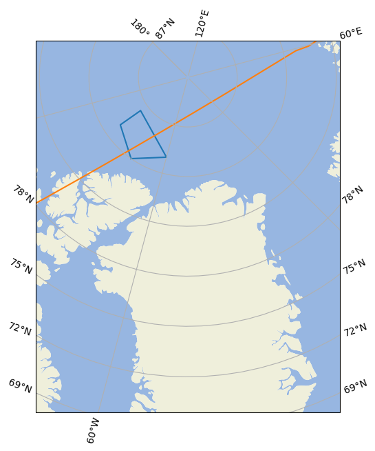
Now that we know the product short_name, we can search for data. Here, I am interested in granules that were collected during the validation campaign. I know there was an underflight of ICESat-2 over sea ice on 26 July 2022, so we will search for ATL07 data for that date.
To search for data, we use earthaccess.search_data. There are many ways to construct a search. Some examples are below.
Currently, processing of ATL07 and ATL10 have been halted because of some issues with input data, so only version 006 is available.
By temporal range
Searching using the temporal filter with short-name and version will return all data granules within the time range specified.
The temporal keyword expects a tuple with two date-like variables. These can be strings following the format YYYY-MM-DD or datetime objects. Because we only want one day of data, the dates are the same.
As with the datasets results, search_data returns a Python List so we can find the number of granules returned using len.
In a Jupyter notebook, we can get a rendering of information about a single granule, including some thumbnails of the location and data just by running a code-cell with one granule result.
We can list those granules in a similar way as we did with the results from search_datasets. We need to know a little about the structure of the granule results. Here, we print the list of granule file names.
We can further refine the search by adding a bounding_box. The coordinates of the bounding box are latitudes and longitudes in WGS84. The bounding_box is a tuple with (min_lon, min_lat, max_lon, max_lat).
Here, we search for ATL07 files in the Arctic.
granules = earthaccess.search_data( short_name="ATL07", temporal=("2022-07-26","2022-07-26"), version="006", bounding_box=(-180., 60., 180., 90.), # To restrict to N.Hem. only)len(granules)
30
Search By Polygon
Searching by bounding-box does not always make sense in the Arctic, where meridians are converging. Defining a polygon might be more useful.
The polygon argument is a Python List of longitude, latitude pairs, with the last pair of points matching the first point. For example:
ICESat-2 data are often referenced by Reference Ground Tracks. Reference Grounds Tracks (RGT) are the imaginary line traced on the surface of the Earth as ICESat-2 passes overhead. There are 1387 RGT. Each RGT is followed once in every 91-day orbit cycle. RGT in different cycles are distinguished by a two digit cycle number. This information is in the file metadata and also encoded in the file name.
where tttt is the four-digit RGT and cc is the cycle number.
Below, we filter the granules to get RGT 0531 by spliting the filename on _ and then looking for the third group of characters (index 2) that starts with 0531.
g = [g for g in granules if g["umm"]['GranuleUR'].split('_')[2].startswith('0531')]g
---------------------------------------------------------------------------IndexError Traceback (most recent call last)
CellIn[16], line 1----> 1 g = [g for g in granules ifg["umm"]['GranuleUR'].split('_')[2].startswith('0531')]
2 g
IndexError: list index out of range
Search by Granule File Name
We can also search for a particular granule. We still need to provide short_name or concept_id becase CMR does not allow searching across collections.
We can either download data to our local machine or stream data directly into memory. Streaming data works well in the cloud.
Below we download data. To stream data, we use the earthaccess.open method.
files = earthaccess.open(granules)
For earthaccess.download, files are downloaded to our current working directory or the directory specified in local_path. A list of the paths to these local files is returned.
If we use earthaccess.open, files is a list of file-like objects.
We’ll use xarray.open_datatree to open the file. Whether we use earthaccess.download or earthaccess.open, the list of file paths or file-like objects in files can be passed to xarray file readers. Currently, xarray.open_datatree will only open a single file, so we have to index files.
files[0]
'data/ATL07-01_20220726161113_05311601_006_02.h5'
decode_timedelta=True is set so that we don’t get a warning.
bin size of fine histogram along track segment length
[1 values with dtype=float32]
delta_h_tab
(phony_dim_21)
float32
...
long_name :
h table spacing
units :
meters
source :
Sea Ice ATBD
contentType :
auxiliaryInformation
description :
the waveform table spacing for the height (h) dimension
[1 values with dtype=float32]
delta_w_tab
(phony_dim_21)
float32
...
long_name :
w table spacing
units :
meters
source :
Sea Ice ATBD
contentType :
auxiliaryInformation
description :
the waveform table spacing for the width (w) dimension
[1 values with dtype=float32]
h_diff_limit
(phony_dim_21)
float32
...
long_name :
Max Ht Difference
units :
meters
source :
Sea Ice ATBD
contentType :
auxiliaryInformation
description :
Maximum height difference between the two weighted Gaussian mean from the initial tracked height (units = meters)
[1 values with dtype=float32]
lb_h_tab
(phony_dim_21)
float32
...
long_name :
lower bound of h table
units :
meters
source :
Sea Ice ATBD
contentType :
auxiliaryInformation
description :
lower bound of h table
[1 values with dtype=float32]
lb_oc_switch_strong
(phony_dim_21)
float32
...
long_name :
Lower bound of overlapping control for strong beam
contentType :
auxiliaryInformation
description :
Lower bound of photon rate overlapping control for strong beam when overlap is turned off
units :
photons/shot
source :
ATBD section 4.2.2.4
[1 values with dtype=float32]
lb_oc_switch_weak
(phony_dim_21)
float32
...
long_name :
Lower bound of overlapping control for weak beam
units :
photons/shot
source :
ATBD section 4.2.2.4
contentType :
auxiliaryInformation
description :
Lower bound of photon rate overlapping control for weak beam when overlap is turned off
[1 values with dtype=float32]
lb_w_tab
(phony_dim_21)
float32
...
long_name :
lower bound of w table
units :
meters
source :
Sea Ice ATBD
contentType :
auxiliaryInformation
description :
lower bound of w table
[1 values with dtype=float32]
lb_win_s
(phony_dim_21)
float32
...
long_name :
lower bound window signal
units :
meters
contentType :
auxiliaryInformation
description :
window (Ws) containing signal photons
source :
Sea Ice ATBD
[1 values with dtype=float32]
n_photon_min
(phony_dim_21)
float32
...
long_name :
Minimum number of photons
units :
1
source :
Sea Ice ATBD
contentType :
auxiliaryInformation
description :
Minimum fraction of photons needed for tracking
[1 values with dtype=float32]
n_photon_trim
(phony_dim_21)
int32
...
long_name :
Min Photons
units :
1
source :
Sea Ice ATBD
contentType :
auxiliaryInformation
description :
Minimum number of photons for trimming leading/trailing bins
[1 values with dtype=int32]
n_s
(phony_dim_21)
int32
...
long_name :
number photons in W_s
units :
1
source :
Sea Ice ATBD
contentType :
auxiliaryInformation
description :
Number of photons to collect within W_s fine tracking window
[1 values with dtype=int32]
n_spec_scale
(phony_dim_21)
float32
...
long_name :
Specular Scaling Value
units :
1
source :
Sea Ice ATBD
contentType :
auxiliaryInformation
description :
Scalling parameter used for scaling value of N_SPECULAR for the weak beam. Specular returns for weak beam are defined as a shot having more photons than (N_SPECULAR/N_SPEC_SCALE)
[1 values with dtype=float32]
n_specular
(phony_dim_21)
float32
...
long_name :
number photons Specular returns
units :
1
source :
Sea Ice ATBD
contentType :
auxiliaryInformation
description :
Specular returns limits
[1 values with dtype=float32]
n_w
(phony_dim_21)
int32
...
long_name :
number of standard deviations
units :
1
source :
Sea Ice ATBD
contentType :
auxiliaryInformation
description :
number of standard deviations
[1 values with dtype=int32]
overlap_switch
(phony_dim_21)
int32
...
long_name :
Overlap Segments
units :
1
source :
Sea Ice ATBD
valid_min :
0
valid_max :
1
contentType :
auxiliaryInformation
description :
Use of overlapping height segments (1 = yes, 0 = no)
flag_meanings :
no yes
flag_values :
[0 1]
[1 values with dtype=int32]
tep_used_gt1_strong
(phony_dim_21)
int32
...
long_name :
TEP Table PCE1_Strong
units :
1
source :
Sea Ice ATBD
contentType :
auxiliaryInformation
description :
TEP used in table generation for strong beam of ground track 1 (1 or 3)
[1 values with dtype=int32]
tep_used_gt1_weak
(phony_dim_21)
int32
...
long_name :
TEP Table PCE1_Weak
units :
1
source :
Sea Ice ATBD
contentType :
auxiliaryInformation
description :
TEP used in table generation for weak beam of ground track 1 (1 or 3)
[1 values with dtype=int32]
tep_used_gt2_strong
(phony_dim_21)
int32
...
long_name :
TEP Table PCE2_Strong
units :
1
source :
Sea Ice ATBD
contentType :
auxiliaryInformation
description :
TEP used in table generation for strong beam of ground track 2 (1 or 3)
[1 values with dtype=int32]
tep_used_gt2_weak
(phony_dim_21)
int32
...
long_name :
TEP Table PCE2_Weak
units :
1
source :
Sea Ice ATBD
contentType :
auxiliaryInformation
description :
TEP used in table generation for weak beam of ground track 2 (1 or 3)
[1 values with dtype=int32]
tep_used_gt3_strong
(phony_dim_21)
int32
...
long_name :
TEP Table PCE3_Strong
units :
1
source :
Sea Ice ATBD
contentType :
auxiliaryInformation
description :
TEP used in table generation for strong beam of ground track 3 (1 or 3)
[1 values with dtype=int32]
tep_used_gt3_weak
(phony_dim_21)
int32
...
long_name :
TEP Table PCE3_Weak
units :
1
source :
Sea Ice ATBD
contentType :
auxiliaryInformation
description :
TEP used in table generation for weak beam of ground track 3 (1 or 3)
[1 values with dtype=int32]
ub_h_tab
(phony_dim_21)
float32
...
long_name :
upper bound of h table
units :
meters
source :
Sea Ice ATBD
contentType :
auxiliaryInformation
description :
the waveform upper bound for the height (h) dimension
[1 values with dtype=float32]
ub_length_strong
(phony_dim_21)
int32
...
long_name :
upper bound segment length strong
units :
1
source :
Sea Ice ATBD
contentType :
auxiliaryInformation
description :
upper bound of segment length strong beam
[1 values with dtype=int32]
ub_length_weak
(phony_dim_21)
int32
...
long_name :
upper bound segment length weak
units :
1
source :
Sea Ice ATBD
contentType :
auxiliaryInformation
description :
upper bound of segment length weak beam
[1 values with dtype=int32]
ub_oc_switch_strong
(phony_dim_21)
float32
...
long_name :
Upper bound of overlapping control for strong beam
units :
photons/shot
source :
ATBD section 4.2.2.4
contentType :
auxiliaryInformation
description :
Upper bound of photon rate overlapping control for strong beam when overlap is turned off
[1 values with dtype=float32]
ub_oc_switch_weak
(phony_dim_21)
float32
...
long_name :
Upper bound of overlapping control for weak beam
units :
photons/shot
source :
ATBD section 4.2.2.4
contentType :
auxiliaryInformation
description :
Upper bound of photon rate overlapping control for weak beam when overlap is turned off
[1 values with dtype=float32]
ub_w_tab
(phony_dim_21)
float32
...
long_name :
upper bound of w table
units :
meters
source :
Sea Ice ATBD
contentType :
auxiliaryInformation
description :
the waveform upper bound for the width (w) dimension
[1 values with dtype=float32]
ub_win_s
(phony_dim_21)
float32
...
long_name :
upper bound window signal
units :
meters
source :
Sea Ice ATBD
contentType :
auxiliaryInformation
description :
window (Ws) containing signal photons
[1 values with dtype=float32]
Description :
Contains ancillary parameters related to the fine surface finding algorithm.
Indicates the maximum segment_id to process (if specified in control). The actual maximum processed may be greater than specified.
[1 values with dtype=int32]
geoseg_min
(phony_dim_22)
int32
...
long_name :
Minimum Segment ID
units :
1
source :
Operations
contentType :
auxiliaryInformation
description :
Indicates the minimum segment_id to process (if specified in control)
[1 values with dtype=int32]
inverted_barometer_switch
(phony_dim_22)
int32
...
long_name :
Inverted Barometer Switch
standard_name :
inverted_barometer_switch
units :
1
source :
Operations
valid_min :
0
valid_max :
1
contentType :
auxiliaryInformation
description :
Switch determines which value of inverted barometer to use to correct photon heights before processing. If switch = 0, use inverted barometer computed using static mean_ocean_slp (1013.25 PA). If switch = 1, use dynamic inverted barometer computed using computed mean_ocean_slp (from ANC10 and ANC48, ancillary_data/sea_ice/mean_ocean_slp).
Switch which determines how ssh height threshold is determined.
[1 values with dtype=int32]
class_noise_level
(phony_dim_23)
float32
...
long_name :
surface classification elevation maximum
standard_name :
class_elev_max
units :
m
source :
Sea Ice ATBD
contentType :
auxiliaryInformation
description :
Surface classification height noise level.
[1 values with dtype=float32]
contrast_filter_percentile
(phony_dim_23)
float32
...
long_name :
percintile of photon rate for contrast filter
standard_name :
contrast_filter_percentile
units :
1
source :
Sea Ice ATBD
contentType :
auxiliaryInformation
description :
percentile of collected photon rates to use in computation of contrast ratio
[1 values with dtype=float32]
contrast_filter_segment_type
(phony_dim_23)
int32
...
long_name :
segment types used for contrast filter
units :
1
source :
Sea Ice ATBD
standard_name :
contrast_filter_seg_type
contentType :
auxiliaryInformation
description :
Segment types used for collecting photon rates used in computing contrast ratio. If set to 0, all segment types are included. If set to 1, only sea ice segments used.
flag_meanings :
all_segments sea_ice_segments_only
flag_values :
[0 1]
[1 values with dtype=int32]
contrast_length_scale
(phony_dim_23)
float32
...
long_name :
Length around segment for contrast filter
standard_name :
pr_ratio_extent
units :
km
source :
Sea Ice ATBD
contentType :
auxiliaryInformation
description :
Before/after along-track distance from segment for calculating the contrast ratio (km)
[1 values with dtype=float32]
height_pct
(phony_dim_23)
float32
...
long_name :
Percentile Hts
units :
percentile
source :
Sea Ice ATBD
contentType :
auxiliaryInformation
description :
Percentile of sorted heights
[1 values with dtype=float32]
max_incidence_angle
(phony_dim_23)
float32
...
long_name :
max incidence angle
units :
degrees
source :
ATBD section 4.3.1.4
contentType :
auxiliaryInformation
description :
maximum beam incidence angle for surface classification/freeboard calculation. If incidence angle (complement of beam_coelev angle) is greater than max_incidence_angle, height_segment_type will be set to -1.
[1 values with dtype=float32]
p1
(phony_dim_23)
float32
...
long_name :
pr (clouds)
units :
1
source :
Sea Ice ATBD
contentType :
auxiliaryInformation
description :
photon rate (clouds)
[1 values with dtype=float32]
p2
(phony_dim_23)
float32
...
long_name :
pr (snow)
units :
1
source :
Sea Ice ATBD
contentType :
auxiliaryInformation
description :
photon rate (snow)
[1 values with dtype=float32]
p3
(phony_dim_23)
float32
...
long_name :
pr (shadow)
units :
1
source :
Sea Ice ATBD
contentType :
auxiliaryInformation
description :
photon rate (shadow)
[1 values with dtype=float32]
p4
(phony_dim_23)
float32
...
long_name :
pr (specular)
units :
1
source :
Sea Ice ATBD
contentType :
auxiliaryInformation
description :
photon rate (specular)
[1 values with dtype=float32]
pr_ratio_extent
(phony_dim_23)
int32
...
long_name :
Number of segments to examine around a dark lead segment for filtering
standard_name :
pr_ratio_extent
units :
count
source :
ATBD section 4.3.1.4
contentType :
auxiliaryInformation
description :
Number of segments to examine both before and after a dark lead segment when filtering dark leads. (DEFUNCT)
[1 values with dtype=int32]
ssh_proc_length
(phony_dim_23)
float32
...
long_name :
sea surface height process length
units :
m
source :
Sea Ice ATBD
contentType :
auxiliaryInformation
description :
length in meters of processing interval when performing surface classification
[1 values with dtype=float32]
th_pr_ratio
(phony_dim_23)
float32
...
long_name :
Minimum photon rate ratio for filtering
standard_name :
th_pr_ratio
units :
count
source :
ATBD section 4.3.1.4
contentType :
auxiliaryInformation
description :
Photon rate ratio used to determine if lead candidate should be filtered.
[1 values with dtype=float32]
theta_cntl
(phony_dim_23)
float32
...
long_name :
Solar elevation for use of background rate
units :
1
source :
Sea Ice ATBD
contentType :
auxiliaryInformation
description :
Solar elevation for controlling use of background rate
[1 values with dtype=float32]
theta_nlb
(phony_dim_23)
float32
...
long_name :
Solar elevation normalization lower bound
units :
degrees
source :
ATBD section 4.3.1.4
contentType :
auxiliaryInformation
description :
Solar elevation normalization lower bound for use of normalized background rate
[1 values with dtype=float32]
theta_ref
(phony_dim_23)
float32
...
long_name :
Solar elevation normalization angle
units :
degrees
source :
ATBD section 4.3.1.4
contentType :
auxiliaryInformation
description :
Solar elevation normalization angle for use of normalized background rate
[1 values with dtype=float32]
w1
(phony_dim_23)
float32
...
long_name :
max width (dark smooth lead)
units :
meters
source :
Sea Ice ATBD
contentType :
auxiliaryInformation
description :
max width (dark smooth lead)
[1 values with dtype=float32]
w2
(phony_dim_23)
float32
...
long_name :
max width (dark rough lead)
units :
meters
source :
Sea Ice ATBD
contentType :
auxiliaryInformation
description :
max width (dark rough lead)
[1 values with dtype=float32]
Description :
Contains ancillary parameters related to the surface classification algorithm.
phony_dim_25: 1
atlas_sdp_gps_epoch
(phony_dim_25)
datetime64[ns]
...
long_name :
ATLAS Epoch Offset
source :
Operations
contentType :
auxiliaryInformation
description :
Number of GPS seconds between the GPS epoch (1980-01-06T00:00:00.000000Z UTC) and the ATLAS Standard Data Product (SDP) epoch (2018-01-01:T00.00.00.000000 UTC). Add this value to delta time parameters to compute full gps_seconds (relative to the GPS epoch) for each data point.
[1 values with dtype=datetime64[ns]]
control
(phony_dim_25)
<U100000
...
long_name :
Control File
units :
1
source :
Operations
contentType :
auxiliaryInformation
description :
PGE-specific control file used to generate this granule. To re-use, replace breaks (BR) with linefeeds.
[1 values with dtype=<U100000]
data_end_utc
(phony_dim_25)
<U27
...
long_name :
End UTC Time of Granule (CCSDS-A, Actual)
units :
1
source :
Derived
contentType :
auxiliaryInformation
description :
UTC (in CCSDS-A format) of the last data point within the granule.
[1 values with dtype=<U27]
data_start_utc
(phony_dim_25)
<U27
...
long_name :
Start UTC Time of Granule (CCSDS-A, Actual)
units :
1
source :
Derived
contentType :
auxiliaryInformation
description :
UTC (in CCSDS-A format) of the first data point within the granule.
[1 values with dtype=<U27]
end_cycle
(phony_dim_25)
int32
...
long_name :
Ending Cycle
units :
1
source :
Derived
valid_min :
0
valid_max :
99
contentType :
auxiliaryInformation
description :
The ending cycle number associated with the data contained within this granule. The cycle number is the counter of the number of 91-day repeat cycles completed by the mission.
[1 values with dtype=int32]
end_delta_time
(phony_dim_25)
datetime64[ns]
...
long_name :
ATLAS End Time (Actual)
standard_name :
time
source :
Derived
contentType :
auxiliaryInformation
description :
Number of GPS seconds since the ATLAS SDP epoch at the last data point in the file. The ATLAS Standard Data Products (SDP) epoch offset is defined within /ancillary_data/atlas_sdp_gps_epoch as the number of GPS seconds between the GPS epoch (1980-01-06T00:00:00.000000Z UTC) and the ATLAS SDP epoch. By adding the offset contained within atlas_sdp_gps_epoch to delta time parameters, the time in gps_seconds relative to the GPS epoch can be computed.
[1 values with dtype=datetime64[ns]]
end_geoseg
(phony_dim_25)
int32
...
long_name :
Ending Geolocation Segment
units :
1
source :
Derived
contentType :
auxiliaryInformation
description :
The ending geolocation segment number associated with the data contained within this granule. ICESat granule geographic regions are further refined by geolocation segments. During the geolocation process, a geolocation segment is created approximately every 20m from the start of the orbit to the end. The geolocation segments help align the ATLAS strong a weak beams and provide a common segment length for the L2 and higher products. The geolocation segment indices differ slightly from orbit-to-orbit because of the irregular shape of the Earth. The geolocation segment indices on ATL01 and ATL02 are only approximate because beams have not been aligned at the time of their creation.
[1 values with dtype=int32]
end_gpssow
(phony_dim_25)
timedelta64[ns]
...
long_name :
Ending GPS SOW of Granule (Actual)
source :
Derived
contentType :
auxiliaryInformation
description :
GPS seconds-of-week of the last data point in the granule.
[1 values with dtype=timedelta64[ns]]
end_gpsweek
(phony_dim_25)
int32
...
long_name :
Ending GPSWeek of Granule (Actual)
units :
weeks from 1980-01-06
source :
Derived
contentType :
auxiliaryInformation
description :
GPS week number of the last data point in the granule.
[1 values with dtype=int32]
end_orbit
(phony_dim_25)
int32
...
long_name :
Ending Orbit Number
units :
1
source :
Derived
contentType :
auxiliaryInformation
description :
The ending orbit number associated with the data contained within this granule. The orbit number increments each time the spacecraft completes a full orbit of the Earth.
[1 values with dtype=int32]
end_region
(phony_dim_25)
int32
...
long_name :
Ending Region
units :
1
source :
Derived
contentType :
auxiliaryInformation
description :
The ending product-specific region number associated with the data contained within this granule. ICESat-2 data products are separated by geographic regions. The data contained within a specific region are the same for ATL01 and ATL02. ATL03 regions differ slightly because of different geolocation segment locations caused by the irregular shape of the Earth. The region indices for other products are completely independent.
[1 values with dtype=int32]
end_rgt
(phony_dim_25)
int32
...
long_name :
Ending Reference Groundtrack
units :
1
source :
Derived
valid_min :
1
valid_max :
1387
contentType :
auxiliaryInformation
description :
The ending reference groundtrack (RGT) number associated with the data contained within this granule. There are 1387 reference groundtrack in the ICESat-2 repeat orbit. The reference groundtrack increments each time the spacecraft completes a full orbit of the Earth and resets to 1 each time the spacecraft completes a full cycle.
[1 values with dtype=int32]
granule_end_utc
(phony_dim_25)
<U27
...
long_name :
End UTC Time of Granule (CCSDS-A, Requested)
units :
1
source :
Derived
contentType :
auxiliaryInformation
description :
Requested end time (in UTC CCSDS-A) of this granule.
[1 values with dtype=<U27]
granule_start_utc
(phony_dim_25)
<U27
...
long_name :
Start UTC Time of Granule (CCSDS-A, Requested)
units :
1
source :
Derived
contentType :
auxiliaryInformation
description :
Requested start time (in UTC CCSDS-A) of this granule.
[1 values with dtype=<U27]
qa_at_interval
(phony_dim_25)
float64
...
long_name :
QA Along-Track Interval
units :
1
source :
control
contentType :
auxiliaryInformation
description :
Statistics time interval for along-track QA data.
[1 values with dtype=float64]
release
(phony_dim_25)
<U80
...
long_name :
Release Number
units :
1
source :
Operations
contentType :
auxiliaryInformation
description :
Release number of the granule. The release number is incremented when the software or ancillary data used to create the granule has been changed.
[1 values with dtype=<U80]
start_cycle
(phony_dim_25)
int32
...
long_name :
Starting Cycle
units :
1
source :
Derived
valid_min :
0
valid_max :
99
contentType :
auxiliaryInformation
description :
The starting cycle number associated with the data contained within this granule. The cycle number is the counter of the number of 91-day repeat cycles completed by the mission.
[1 values with dtype=int32]
start_delta_time
(phony_dim_25)
datetime64[ns]
...
long_name :
ATLAS Start Time (Actual)
standard_name :
time
source :
Derived
contentType :
auxiliaryInformation
description :
Number of GPS seconds since the ATLAS SDP epoch at the first data point in the file. The ATLAS Standard Data Products (SDP) epoch offset is defined within /ancillary_data/atlas_sdp_gps_epoch as the number of GPS seconds between the GPS epoch (1980-01-06T00:00:00.000000Z UTC) and the ATLAS SDP epoch. By adding the offset contained within atlas_sdp_gps_epoch to delta time parameters, the time in gps_seconds relative to the GPS epoch can be computed.
[1 values with dtype=datetime64[ns]]
start_geoseg
(phony_dim_25)
int32
...
long_name :
Starting Geolocation Segment
units :
1
source :
Derived
contentType :
auxiliaryInformation
description :
The starting geolocation segment number associated with the data contained within this granule. ICESat granule geographic regions are further refined by geolocation segments. During the geolocation process, a geolocation segment is created approximately every 20m from the start of the orbit to the end. The geolocation segments help align the ATLAS strong a weak beams and provide a common segment length for the L2 and higher products. The geolocation segment indices differ slightly from orbit-to-orbit because of the irregular shape of the Earth. The geolocation segment indices on ATL01 and ATL02 are only approximate because beams have not been aligned at the time of their creation.
[1 values with dtype=int32]
start_gpssow
(phony_dim_25)
timedelta64[ns]
...
long_name :
Start GPS SOW of Granule (Actual)
source :
Derived
contentType :
auxiliaryInformation
description :
GPS seconds-of-week of the first data point in the granule.
[1 values with dtype=timedelta64[ns]]
start_gpsweek
(phony_dim_25)
int32
...
long_name :
Start GPSWeek of Granule (Actual)
units :
weeks from 1980-01-06
source :
Derived
contentType :
auxiliaryInformation
description :
GPS week number of the first data point in the granule.
[1 values with dtype=int32]
start_orbit
(phony_dim_25)
int32
...
long_name :
Starting Orbit Number
units :
1
source :
Derived
contentType :
auxiliaryInformation
description :
The starting orbit number associated with the data contained within this granule. The orbit number increments each time the spacecraft completes a full orbit of the Earth.
[1 values with dtype=int32]
start_region
(phony_dim_25)
int32
...
long_name :
Starting Region
units :
1
source :
Derived
contentType :
auxiliaryInformation
description :
The starting product-specific region number associated with the data contained within this granule. ICESat-2 data products are separated by geographic regions. The data contained within a specific region are the same for ATL01 and ATL02. ATL03 regions differ slightly because of different geolocation segment locations caused by the irregular shape of the Earth. The region indices for other products are completely independent.
[1 values with dtype=int32]
start_rgt
(phony_dim_25)
int32
...
long_name :
Starting Reference Groundtrack
units :
1
source :
Derived
valid_min :
1
valid_max :
1387
contentType :
auxiliaryInformation
description :
The starting reference groundtrack (RGT) number associated with the data contained within this granule. There are 1387 reference groundtrack in the ICESat-2 repeat orbit. The reference groundtrack increments each time the spacecraft completes a full orbit of the Earth and resets to 1 each time the spacecraft completes a full cycle.
[1 values with dtype=int32]
version
(phony_dim_25)
<U80
...
long_name :
Version
units :
1
source :
Operations
contentType :
auxiliaryInformation
description :
Version number of this granule within the release. It is a sequential number corresponding to the number of times the granule has been reprocessed for the current release.
[1 values with dtype=<U80]
Description :
Contains information ancillary to the data product. This may include product characteristics, instrument characteristics and/or processing constants.
<xarray.DatasetView> Size: 30B
Dimensions:         (crossing_time: 1, sc_orient_time: 1)
Coordinates:
  * crossing_time   (crossing_time) datetime64[ns] 8B 2022-07-26T16:11:14.423...
  * sc_orient_time  (sc_orient_time) datetime64[ns] 8B 2022-07-25T23:30:00
Data variables:
    cycle_number    (crossing_time) int8 1B ...
    lan             (crossing_time) float64 8B ...
    orbit_number    (crossing_time) uint16 2B ...
    rgt             (crossing_time) int16 2B ...
    sc_orient       (sc_orient_time) int8 1B ...
Attributes:
    Description:  Contains orbit information.
    data_rate:    Varies. Data are only provided when one of the stored value...
orbit_info
crossing_time: 1
sc_orient_time: 1
crossing_time
(crossing_time)
datetime64[ns]
2022-07-26T16:11:14.423833936
long_name :
Ascending Node Crossing Time
standard_name :
time
source :
POD/PPD
contentType :
referenceInformation
description :
The time, in seconds since the ATLAS SDP GPS Epoch, at which the ascending node crosses the equator. The ATLAS Standard Data Products (SDP) epoch offset is defined within /ancillary_data/atlas_sdp_gps_epoch as the number of GPS seconds between the GPS epoch (1980-01-06T00:00:00.000000Z UTC) and the ATLAS SDP epoch. By adding the offset contained within atlas_sdp_gps_epoch to delta time parameters, the time in gps_seconds relative to the GPS epoch can be computed.
The time of the last spacecraft orientation change between forward, backward and transitional flight modes, expressed in seconds since the ATLAS SDP GPS Epoch. ICESat-2 is considered to be flying forward when the weak beams are leading the strong beams; and backward when the strong beams are leading the weak beams. ICESat-2 is considered to be in transition while it is maneuvering between the two orientations. Science quality is potentially degraded while in transition mode. The ATLAS Standard Data Products (SDP) epoch offset is defined within /ancillary_data/atlas_sdp_gps_epoch as the number of GPS seconds between the GPS epoch (1980-01-06T00:00:00.000000Z UTC) and the ATLAS SDP epoch. By adding the offset contained within atlas_sdp_gps_epoch to delta time parameters, the time in gps_seconds relative to the GPS epoch can be computed.
A count of the number of exact repeats of this reference orbit.
[1 values with dtype=int8]
lan
(crossing_time)
float64
...
long_name :
Ascending Node Longitude
units :
degrees_east
source :
POD/PPD
valid_min :
-180.0
valid_max :
180.0
contentType :
referenceInformation
description :
Longitude at the ascending node crossing.
[1 values with dtype=float64]
orbit_number
(crossing_time)
uint16
...
long_name :
Orbit Number
units :
1
source :
Operations
valid_min :
1
valid_max :
65000
contentType :
referenceInformation
description :
Unique identifying number for each planned ICESat-2 orbit.
[1 values with dtype=uint16]
rgt
(crossing_time)
int16
...
long_name :
Reference Ground track
units :
1
source :
POD/PPD
valid_min :
1
valid_max :
1387
contentType :
referenceInformation
description :
The reference ground track (RGT) is the track on the earth at which a specified unit vector within the observatory is pointed. Under nominal operating conditions, there will be no data collected along the RGT, as the RGT is spanned by GT3 and GT4. During slews or off-pointing, it is possible that ground tracks may intersect the RGT. The ICESat-2 mission has 1387 RGTs.
[1 values with dtype=int16]
sc_orient
(sc_orient_time)
int8
...
long_name :
Spacecraft Orientation
units :
1
source :
POD/PPD
valid_min :
0
valid_max :
2
contentType :
referenceInformation
description :
This parameter tracks the spacecraft orientation between forward, backward and transitional flight modes. ICESat-2 is considered to be flying forward when the weak beams are leading the strong beams; and backward when the strong beams are leading the weak beams. ICESat-2 is considered to be in transition while it is maneuvering between the two orientations. Science quality is potentially degraded while in transition mode.
flag_meanings :
backward forward transition
flag_values :
[0 1 2]
[1 values with dtype=int8]
Description :
Contains orbit information.
data_rate :
Varies. Data are only provided when one of the stored values (besides time) changes.
<xarray.DatasetView> Size: 8B
Dimensions:                 (phony_dim_26: 1)
Dimensions without coordinates: phony_dim_26
Data variables:
    qa_granule_fail_reason  (phony_dim_26) int32 4B ...
    qa_granule_pass_fail    (phony_dim_26) int32 4B ...
Attributes:
    Description:  Contains quality assessment data. This may include QA count...
quality_assessment
phony_dim_26: 1
qa_granule_fail_reason
(phony_dim_26)
int32
...
long_name :
Granule Failure Reason
units :
1
source :
Operations
valid_min :
0
valid_max :
5
contentType :
qualityInformation
description :
Flag indicating granule failure reason. 0=no failure; 1=processing error; 2=Insufficient output data was generated; 3=TBD Failure; 4=TBD_Failure; 5=other failure.
Contains quality assessment data. This may include QA counters, QA along-track data and/or QA summary data.
...
<xarray.DatasetView> Size: 0B
Dimensions:  ()
Data variables:
    *empty*
Attributes:
    Description:         This ground contains parameters and subgroups relate...
    data_rate:           Each subgroup identifies its particular data rate.
    atlas_pce:           pce2
    atlas_beam_type:     strong
    groundtrack_id:      gt2r
    atmosphere_profile:  profile_2
    atlas_spot_number:   3
    sc_orientation:      Forward
gt2r
<xarray.DatasetView> Size: 4MB
Dimensions:            (delta_time: 100614)
Coordinates:
  * delta_time         (delta_time) datetime64[ns] 805kB 2022-07-26T16:28:36....
    latitude           (delta_time) float64 805kB ...
    longitude          (delta_time) float64 805kB ...
Data variables:
    geoseg_beg         (delta_time) int32 402kB ...
    geoseg_end         (delta_time) int32 402kB ...
    height_segment_id  (delta_time) int32 402kB ...
    seg_dist_x         (delta_time) float64 805kB ...
Attributes:
    Description:  Top group for sea ice segments as computed by the ATBD aglo...
    data_rate:    Data within this group are stored at the variable segment r...
sea_ice_segments
<xarray.DatasetView> Size: 4MB
Dimensions:                     (delta_time: 100614)
Coordinates:
  * delta_time                  (delta_time) datetime64[ns] 805kB 2022-07-26T...
Data variables:
    beam_azimuth                (delta_time) float32 402kB ...
    beam_coelev                 (delta_time) float32 402kB ...
    height_segment_podppd_flag  (delta_time) float32 402kB ...
    rgt                         (delta_time) int16 201kB ...
    sigma_h                     (delta_time) float32 402kB ...
    sigma_lat                   (delta_time) float32 402kB ...
    sigma_lon                   (delta_time) float32 402kB ...
    solar_azimuth               (delta_time) float32 402kB ...
    solar_elevation             (delta_time) float32 402kB ...
Attributes:
    Description:  Contains parameters related to geolocation.
    data_rate:    Data within this group are stored at the sea_ice_height seg...
geolocation
delta_time: 100614
beam_azimuth
(delta_time)
float32
...
long_name :
beam azimuth
units :
degrees_east
source :
Sea Ice ATBD
contentType :
referenceInformation
description :
The direction, eastwards from north, of the laser beam vector as seen by an observer at the laser ground spot viewing toward the spacecraft (i.e., the vector from the ground to the spacecraft). When the spacecraft is precisely at the geodetic zenith, the value will be 99999 degrees.
[100614 values with dtype=float32]
beam_coelev
(delta_time)
float32
...
long_name :
beam co-elevation
units :
radians
source :
Sea Ice ATBD
contentType :
referenceInformation
description :
Co-elevation (CE) is direction from the plane of the laser beam as seen by an observer located at the laser ground spot.
[100614 values with dtype=float32]
height_segment_podppd_flag
(delta_time)
float32
...
long_name :
POD_PPD Flag
units :
1
source :
ATL02, ANC04, ANC05, ATL03
valid_min :
0
valid_max :
7
contentType :
referenceInformation
description :
Composite POD/PPD flag from ATL03 that indicates the quality of input geolocation products. Value is set as the highest podppd_flag value from ATL03 associated with this segment. A non-zero value may indicate that geolocation solutions are degraded or that ATLAS is within a calibration scan period (CAL). Possible non-CAL values are: 0=NOMINAL; 1=POD_DEGRADE; 2=PPD_DEGRADE; 3=PODPPD_DEGRADE; possible CAL values are: 4=CAL_NOMINAL; 5=CAL_POD_DEGRADE; 6=CAL_PPD_DEGRADE; 7=CAL_PODPPD_DEGRADE.
[100614 values with dtype=float32]
rgt
(delta_time)
int16
...
long_name :
Reference Ground track
units :
1
source :
Sea Ice ATBD
valid_min :
1
valid_max :
1387
contentType :
referenceInformation
description :
The reference ground track (RGT) is the track on the earth at which a specified unit vector within the observatory is pointed. Under nominal operating conditions, there will be no data collected along the RGT, as the RGT is spanned by GT3 and GT4. During slews or off-pointing, it is possible that ground tracks may intersect the RGT. The ICESat-2 mission has 1387 RGTs.
[100614 values with dtype=int16]
sigma_h
(delta_time)
float32
...
long_name :
height uncertainty
units :
1
source :
Sea Ice ATBD
contentType :
referenceInformation
description :
Estimated uncertainty for the reference photon bounce point ellipsoid height: 1- sigma (m). Error estimates for all other photons in the group are computed with the scale defined below.
[100614 values with dtype=float32]
sigma_lat
(delta_time)
float32
...
long_name :
latitude uncertainty
units :
1
source :
Sea Ice ATBD
contentType :
referenceInformation
description :
Estimated uncertainty for the reference photon bounce point geodetic latitude: 1- sigma (degrees). Applies to all other photons in the group
[100614 values with dtype=float32]
sigma_lon
(delta_time)
float32
...
long_name :
longitude uncertainty
units :
degrees
source :
Sea Ice ATBD
contentType :
referenceInformation
description :
Estimated uncertainty for the reference photon bounce point east longitude: 1- sigma (degrees). Applies to all other photons in the group.
[100614 values with dtype=float32]
solar_azimuth
(delta_time)
float32
...
long_name :
solar azimuth
units :
degrees_east
source :
Sea Ice ATBD
contentType :
auxiliaryInformation
description :
The direction, eastwards from north, of the sun vector as seen by an observer at the laser ground spot.
[100614 values with dtype=float32]
solar_elevation
(delta_time)
float32
...
long_name :
solar elevation
source :
Sea Ice ATBD
contentType :
auxiliaryInformation
description :
Solar Angle above or below the plane tangent to the ellipsoid surface at the laser spot. Positive values mean the sun is above the horizon, while negative values mean it is below the horizon. The effect of atmospheric refraction is not included. This is a low precision value, with approximately TBD degree accuracy.
units :
degrees
[100614 values with dtype=float32]
Description :
Contains parameters related to geolocation.
data_rate :
Data within this group are stored at the sea_ice_height segment rate.
<xarray.DatasetView> Size: 9MB
Dimensions:                          (delta_time: 100614)
Coordinates:
  * delta_time                       (delta_time) datetime64[ns] 805kB 2022-0...
Data variables: (12/18)
    height_segment_dac               (delta_time) float32 402kB ...
    height_segment_dynib             (delta_time) float32 402kB ...
    height_segment_earth             (delta_time) float32 402kB ...
    height_segment_earth_free2mean   (delta_time) float32 402kB ...
    height_segment_geoid             (delta_time) float32 402kB ...
    height_segment_geoid_free2mean   (delta_time) float32 402kB ...
    ...                               ...
    height_segment_pole              (delta_time) float32 402kB ...
    height_segment_ps                (delta_time) float32 402kB ...
    height_segment_t2m               (delta_time) float32 402kB ...
    height_segment_tide_interp_flag  (delta_time) float64 805kB ...
    height_segment_u2m               (delta_time) float32 402kB ...
    height_segment_v2m               (delta_time) float32 402kB ...
Attributes:
    Description:  Contains geophysical parameters and corrections used to cor...
    data_rate:    Data within this group are stored at the sea_ice_height seg...
geophysical
delta_time: 100614
height_segment_dac
(delta_time)
float32
...
units :
meters
long_name :
Dynamic Atmosphere Correction
source :
Sea Ice ATBD
contentType :
referenceInformation
description :
Dynamic Atmospheric Correction (DAC) includes inverted barometer (IB) effect.
[100614 values with dtype=float32]
height_segment_dynib
(delta_time)
float32
...
long_name :
Dynamic inverted barometer effect
standard_name :
dynamic inverted baromter
units :
meters
source :
ATBD, section 4.2
contentType :
referenceInformation
description :
Inverted barometer effect calculated from dynamic mean ocean sea level pressure (computed using ANC10 and ANC48, /ancillary_data/sea_ice/mean_ocean_slp)
[100614 values with dtype=float32]
height_segment_earth
(delta_time)
float32
...
units :
meters
long_name :
Earth Tide
source :
Sea Ice ATBD
contentType :
referenceInformation
description :
Solid Earth Tide. The solid earth tide height is in the tide-free system.
[100614 values with dtype=float32]
height_segment_earth_free2mean
(delta_time)
float32
...
long_name :
Earth Tide Free-to-Mean conversion
units :
meters
source :
Sea Ice ATBD
contentType :
referenceInformation
description :
Additive value to convert solid earth tide from the tide-free system to the mean-tide system. (Add to height_segment_eath to get the solid earth tides in the mean-tide system.)
[100614 values with dtype=float32]
height_segment_geoid
(delta_time)
float32
...
units :
meters
long_name :
EGM2008 Geoid
source :
Sea Ice ATBD
contentType :
referenceInformation
description :
Geoid height above WGS-84 reference ellipsoid (range -107 to 86m), based on the EGM2008 model. The geoid height is in the tide-free system.
[100614 values with dtype=float32]
height_segment_geoid_free2mean
(delta_time)
float32
...
long_name :
EGM2008 Geoid Free-to-Mean conversion
units :
meters
source :
Sea Ice ATBD
contentType :
referenceInformation
description :
Additive value to convert geoid heights from the tide-free system to the mean-tide system. (Add to height_segment_geoid to get the geoid heights in the mean-tide system.)
[100614 values with dtype=float32]
height_segment_ib
(delta_time)
float32
...
long_name :
Inverted barometer effect
units :
meters
source :
ATBD, section 4.2
contentType :
referenceInformation
description :
Inverted barometer effect calculated from surface pressure
[100614 values with dtype=float32]
height_segment_load
(delta_time)
float32
...
long_name :
Load Tide
units :
meters
source :
Sea Ice ATBD
contentType :
referenceInformation
description :
Load Tide - Local displacement due to Ocean Loading (-6 to 0 cm).
[100614 values with dtype=float32]
height_segment_lpe
(delta_time)
float32
...
units :
meters
long_name :
Equilibrium Tide
source :
Sea Ice ATBD
contentType :
referenceInformation
description :
Long period equilibrium tide self-consistent with ocean tide model (+-0.04m). (dependent only on time and latitude)
[100614 values with dtype=float32]
height_segment_mss
(delta_time)
float32
...
long_name :
CryoSat-2/DTU13 Mean Sea Surface (tide free)
units :
meters
source :
Sea Ice ATBD
contentType :
referenceInformation
description :
Mean sea surface height above WGS-84 reference ellipsoid (range: -68 to 65m), based on a CryoSat-2/DTU13 merged product (https://doi.org/10.5281/zenodo.4294047). The MSS height (from ANC15) is adjusted to be in a tide free reference system (subtracting the geoid_free2mean correction) to be consistent with the tide free ATL03 heights.
[100614 values with dtype=float32]
height_segment_mss_interp_flag
(delta_time)
float64
...
long_name :
MSS interpolation flag
standard_name :
mss_interp_flag
units :
1
source :
Sea Ice ATBD
valid_min :
0
valid_max :
2
contentType :
referenceInformation
description :
Flag marking where MSS has been interpolated
flag_meanings :
no_interpolation interpolation extrapolation
flag_values :
[0 1 2]
[100614 values with dtype=float64]
height_segment_ocean
(delta_time)
float32
...
long_name :
Ocean Tide
units :
meters
source :
Sea Ice ATBD
contentType :
referenceInformation
description :
Ocean Tides including diurnal and semi-diurnal (harmonic analysis), and longer period tides (dynamic and self-consistent equilibrium)
[100614 values with dtype=float32]
height_segment_pole
(delta_time)
float32
...
long_name :
Pole Tide
units :
meters
source :
Sea Ice ATBD
contentType :
referenceInformation
description :
Pole Tide -Rotational deformation due to polar motion (-1.5 to 1.5 cm).
[100614 values with dtype=float32]
height_segment_ps
(delta_time)
float32
...
long_name :
sea level pressure
standard_name :
pressure
units :
Pa
source :
ATL09
contentType :
referenceInformation
description :
Sea Level Pressure (Pa)
[100614 values with dtype=float32]
height_segment_t2m
(delta_time)
float32
...
long_name :
temperature_at_2m
standard_name :
temperature
units :
K
source :
ATL09
contentType :
referenceInformation
description :
Temperature at 2m above the displacement height (K)
[100614 values with dtype=float32]
height_segment_tide_interp_flag
(delta_time)
float64
...
long_name :
tide interpolation flag
standard_name :
tide_interp_flag
units :
1
source :
Sea Ice ATBD
valid_min :
0
valid_max :
2
contentType :
referenceInformation
description :
Flag marking where ocean tide and LPE tide has been interpolated
flag_meanings :
no_interpolation interpolation extrapolation
flag_values :
[0 1 2]
[100614 values with dtype=float64]
height_segment_u2m
(delta_time)
float32
...
long_name :
Eastward_wind_at_2m
standard_name :
eastward_wind
units :
m s-1
source :
ATL09
contentType :
referenceInformation
description :
Eastward wind at 2m above the displacement height (m/s-1)
[100614 values with dtype=float32]
height_segment_v2m
(delta_time)
float32
...
long_name :
Northward_wind_at_2m
standard_name :
northward_wind
units :
m s-1
source :
ATL09
contentType :
referenceInformation
description :
Northward wind at 2m above the displacement height (m/s-1)
[100614 values with dtype=float32]
Description :
Contains geophysical parameters and corrections used to correct photon heights for geophysical effects, such as tides.
data_rate :
Data within this group are stored at the sea_ice_height segment rate.
<xarray.DatasetView> Size: 7MB
Dimensions:                           (delta_time: 100614)
Coordinates:
  * delta_time                        (delta_time) datetime64[ns] 805kB 2022-...
Data variables: (12/17)
    across_track_distance             (delta_time) float32 402kB ...
    height_segment_asr_calc           (delta_time) float32 402kB ...
    height_segment_confidence         (delta_time) float32 402kB ...
    height_segment_contrast_ratio     (delta_time) float32 402kB ...
    height_segment_fit_quality_flag   (delta_time) float32 402kB ...
    height_segment_height             (delta_time) float32 402kB ...
    ...                                ...
    height_segment_quality            (delta_time) int8 101kB ...
    height_segment_rms                (delta_time) float32 402kB ...
    height_segment_ssh_flag           (delta_time) int8 101kB ...
    height_segment_surface_error_est  (delta_time) float32 402kB ...
    height_segment_type               (delta_time) int8 101kB ...
    height_segment_w_gaussian         (delta_time) float32 402kB ...
Attributes:
    Description:  Contains parameters relating to the calculated surface heig...
    data_rate:    Data within this group are stored at the sea_ice_height seg...
heights
delta_time: 100614
across_track_distance
(delta_time)
float32
...
long_name :
Across Track Distance
units :
meters
source :
ATBD, section 4.2.4
contentType :
referenceInformation
description :
Across track distance of photons averaged over the sea ice height segment.
[100614 values with dtype=float32]
height_segment_asr_calc
(delta_time)
float32
...
long_name :
Calculated Apparent Surface Reflectivity
units :
1
source :
Sea Ice ATBD
contentType :
referenceInformation
description :
Computed apparent surface reflectance for the sea ice segment.
[100614 values with dtype=float32]
height_segment_confidence
(delta_time)
float32
...
long_name :
Surface height confidence
units :
1
source :
ATBD, section 4.2.4.2
contentType :
referenceInformation
description :
Confidence level in the surface height estimate based on analysis of the error surface, defined as the mean-square difference between the height distribution and expected return (computed waveform table). The height_segment_confidence is computed as ( min(error_surf) - mean(error_surf) ).
[100614 values with dtype=float32]
height_segment_contrast_ratio
(delta_time)
float32
...
long_name :
ratio of maximum photon rate to segment photon rate
standard_name :
contrast_ratio
units :
1
source :
ATBD
contentType :
referenceInformation
description :
Ratio of maximum segment photon rate within an along-track distance of +/- contrast_length_scale to the photon rate of the current segment.
[100614 values with dtype=float32]
height_segment_fit_quality_flag
(delta_time)
float32
...
long_name :
height Quality Flag
units :
1
source :
ATBD, section 4.2.4.2
valid_min :
-1
valid_max :
5
contentType :
referenceInformation
description :
Flag describing the quality of the results of the along-track fit. (-1=height value is invalid; 1=ngrid_w < wlength/2; 2=ngrid_w >= wlength/2; 3=ngrid_dt < dtlength/2; 4=ngrid_dt >= dtlength/2; 5=ngrid_dt >= (dtlength-2): where 1 is best and 5 is poor). Heights are reported even if this flag indicates the height is invalid.
flag_meanings :
invalid best high med low poor
flag_values :
[-1 1 2 3 4 5]
[100614 values with dtype=float32]
height_segment_height
(delta_time)
float32
...
long_name :
height of segment surface
standard_name :
h_surf
units :
meters
source :
ATBD, section 4.2.2.4
contentType :
referenceInformation
description :
Mean height from along-track segment fit determined by the sea ice algorithm. Ocean tides and inverted barometer corrections are also applied (see Appendix J of ATBD). The sea ice height is relative to the tide-free MSS.
[100614 values with dtype=float32]
height_segment_height_uncorr
(delta_time)
float32
...
long_name :
height of segment with no additional geophysical corrections applied in ATL07
standard_name :
h_surf_uncorr
units :
meters
source :
ATBD, section 4.2.2.4
contentType :
referenceInformation
description :
Mean segment height with no additional geophysical corrections applied in ATL07 (see Appendix J of ATBD).
[100614 values with dtype=float32]
height_segment_htcorr_skew
(delta_time)
float32
...
long_name :
Height Correction for Skew
units :
meters
source :
ATBD, section 4.2.6
contentType :
referenceInformation
description :
height corection for skew
[100614 values with dtype=float32]
height_segment_length_seg
(delta_time)
float32
...
long_name :
length of segment
units :
meters
source :
ATBD, section 4.2.2.4
contentType :
referenceInformation
description :
along-track length of segment containing n_photons_actual
[100614 values with dtype=float32]
height_segment_n_pulse_seg
(delta_time)
int32
...
long_name :
number of laser pulses
units :
1
source :
ATBD, section 4.2.2.4
contentType :
referenceInformation
description :
number of laser pulses spanned to gather photons in sea ice segment, including specular returns.
[100614 values with dtype=int32]
height_segment_n_pulse_seg_used
(delta_time)
int32
...
long_name :
number of laser pulses used
units :
1
source :
ATBD, section 4.2.2.4
contentType :
referenceInformation
description :
number of laser pulses used in processing sea ice segment, excluding specular returns. Computed as number of laser pulses spanned (height_segment_n_pulse_seg) - number of specular shots excluded.
[100614 values with dtype=int32]
height_segment_quality
(delta_time)
int8
...
long_name :
Height Segment Quality Flag
units :
1
source :
ATBD, section 4.2.4
valid_min :
0
valid_max :
1
contentType :
referenceInformation
description :
Height segment quality flag, 1 is good quality, 0 is bad depending on fit, wguassian, or layer flag
flag_meanings :
bad_quality good_quality
flag_values :
[0 1]
[100614 values with dtype=int8]
height_segment_rms
(delta_time)
float32
...
long_name :
height rms
units :
meters
source :
ATBD, section 4.2.2.4
contentType :
referenceInformation
description :
RMS difference between sea ice modeled and observed photon height distribution
[100614 values with dtype=float32]
height_segment_ssh_flag
(delta_time)
int8
...
long_name :
Sea Surface Flag
units :
1
source :
ATBD, section 4.3
valid_min :
0
valid_max :
1
contentType :
referenceInformation
description :
Identifies the height segments that are candidates for use as sea surface reference in freeboard calculations in ATL10. 0 = sea ice; 1 = sea surface
flag_meanings :
sea_ice sea_surface
flag_values :
[0 1]
[100614 values with dtype=int8]
height_segment_surface_error_est
(delta_time)
float32
...
long_name :
h surface error est
units :
meters
source :
ATBD, section 4.2.2.4
contentType :
referenceInformation
description :
Error estimate of the surface height
[100614 values with dtype=float32]
height_segment_type
(delta_time)
int8
...
long_name :
Segment surface type
units :
1
source :
ATBD, section 4.3
valid_min :
-1
valid_max :
9
contentType :
referenceInformation
description :
Value that indicates segment surface type as sea ice or different types of sea surface.
Contains parameters relating to the calculated surface height for one Ground Track. As ICESat-2 orbits the earth, sequential transmit pulses illuminate six ground tracks on the surface of the earth.
data_rate :
Data within this group are stored at the sea_ice_height segment rate.
Dimension scale indexing the sea ice histogram bins. The bin heights must be computed from information contained within the same group as the histogram.
Dimension scale indexing the YAPC histogram bins. The histogram contains YAPC weight counts within 6 log-scale bins.
array([1, 2, 3, 4, 5, 6], dtype=int32)
asr_25
(delta_time)
float32
...
long_name :
Apparent Surface Reflectance 25hz
units :
1
source :
Sea Ice ATBD
contentType :
referenceInformation
description :
Apparent surface reflectance at 25 hz, averaged to the sea ice segment.
[100614 values with dtype=float32]
backgr_calc
(delta_time)
float32
...
long_name :
background count rate calculated
units :
hz
source :
ATBD, section 4.2.3
contentType :
referenceInformation
description :
Calculated background count rate based on sun angle, surface slope, unit reflectance
[100614 values with dtype=float32]
backgr_r_200
(delta_time)
float32
...
long_name :
Background rate 200 hz
units :
hz
source :
ATL09
contentType :
referenceInformation
description :
Background count rate, averaged over the segment based on ATLAS 50 pulse counts
[100614 values with dtype=float32]
backgr_r_25
(delta_time)
float32
...
long_name :
Background rate 25hz
units :
hz
source :
ATL09
contentType :
referenceInformation
description :
Background count rate, averaged over the segment based on 25 hz atmosphere
[100614 values with dtype=float32]
background_int_height
(delta_time)
float32
...
long_name :
Height of column used in background calculation
units :
meters
source :
ATBD, section 7.3
contentType :
referenceInformation
description :
The height of the altimetric range window after subtracting the height span of the signal photon events in the 50-shot span
[100614 values with dtype=float32]
background_r_norm
(delta_time)
float32
...
long_name :
Normalized background (50-shot)
units :
hz
source :
ATBD section 4.3.1.3
contentType :
referenceInformation
description :
Background rate normalized to a fixed solar elevation angle
[100614 values with dtype=float32]
bsnow_con
(delta_time)
float32
...
long_name :
Blowing snow confidence
units :
1
source :
ATL09
contentType :
modelResult
description :
Blowing snow confidence
[100614 values with dtype=float32]
bsnow_h
(delta_time)
float32
...
long_name :
Blowing snow top h
units :
meters
source :
ATL09
contentType :
modelResult
description :
Blowing snow layer top height
[100614 values with dtype=float32]
cloud_flag_asr
(delta_time)
float32
...
units :
1
source :
Atmosphere ATBD
long_name :
Cloud Flag ASR
valid_min :
0
valid_max :
6
contentType :
modelResult
description :
Cloud flag (probability) from apparent surface reflectance. 0=clear with high confidence; 1=clear with medium confidence; 2=clear with low confidence; 3=cloudy with low confidence; 4=cloudy with medium confidence; 5=cloudy with high confidence; 6=unknown
This flag is a combination of multiple flags (cloud_flag_atm, cloud_flag_asr, and bsnow_con) and takes daytime/nighttime into consideration. A value of 1 means clouds or blowing snow are likely present. A value of 0 indicates the likely absence of clouds or blowing snow.
flag_meanings :
likely_clear likely_cloudy
flag_values :
[0 1]
[100614 values with dtype=float32]
msw_flag
(delta_time)
float32
...
long_name :
Multiple Scattering Warning Flag
units :
1
source :
Atmosphere ATBD
valid_min :
-1
valid_max :
5
contentType :
modelResult
description :
Multiple Scattering warning flag. The multiple scattering warning flag (ATL09 parameter msw_flag) has values from -1 to 5 where zero means no multiple scattering and 5 the greatest. If no layers were detected, then msw_flag = 0. If blowing snow is detected and its estimated optical depth is greater than or equal to 0.5, then msw_flag = 5. If the blowing snow optical depth is less than 0.5, then msw_flag = 4. If no blowing snow is detected but there are cloud or aerosol layers detected, the msw_flag assumes values of 1 to 3 based on the height of the bottom of the lowest layer: < 1 km, msw_flag = 3; 1-3 km, msw_flag = 2; > 3km, msw_flag = 1. A value of -1 indicates that the signal to noise of the data was too low to reliably ascertain the presence of cloud or blowing snow. We expect values of -1 to occur only during daylight.
Ocean depth (anc43). Note, negative value corresponds to ocean depth, positive value corresponds to above sea level.
[100614 values with dtype=float32]
photon_rate
(delta_time)
float32
...
long_name :
photon rate
units :
photons/shot
source :
ATBD, section 4.2.2.4
contentType :
referenceInformation
description :
Photon rate averaged over sea ice segment. Computed by dividing the number of photons in trimmed histogram (n_photons_used) by the number of used shots (height_segment_n_pulse_seg_used).
[100614 values with dtype=float32]
trim_height_bottom
(delta_time)
float32
...
long_name :
minimum height of trimmed photons
units :
meters
source :
ATBD, section 4.2.2.4
contentType :
referenceInformation
description :
minimum height of trimmed photons used in the surface calculation procedure
[100614 values with dtype=float32]
trim_height_top
(delta_time)
float32
...
long_name :
maximum height of trimmed photons
units :
meters
source :
ATBD, section 4.2.2.4
contentType :
referenceInformation
description :
maximum height of trimmed photons used in the surface calculation procedure
[100614 values with dtype=float32]
yapc_knn_mean
(delta_time)
float32
...
long_name :
mean YAPC KNN value
standard_name :
yapc_knn_mean
units :
1
source :
Sea Ice ATBD
contentType :
referenceInformation
description :
Mean YAPC KNN value from ATL03 gooses used in the ATL07 segment
[100614 values with dtype=float32]
yapc_weight_ph_cts_n
(delta_time, ds_yapc_hist_bins)
int16
...
long_name :
YAPC photon weights histogram
standard_name :
yapc_weight_ph_cts_n
units :
1
source :
ATBD, section 4.2.2.4
contentType :
referenceInformation
description :
YAPC weight counts within 6 log-scale bins using all aggregated photons (bin1: 0-56, bin2: 57-133, bin3: 134-178, bin4: 179-210, bin5: 211-234, bin6: 235-255)
[603684 values with dtype=int16]
yapc_weight_ph_mean_actual
(delta_time)
float32
...
long_name :
mean YAPC weight from all aggregrated photons
standard_name :
yapc_weight_ph_mean_actual
units :
1
source :
Sea Ice ATBD
contentType :
referenceInformation
description :
Mean YAPC weights from all photons aggregated within the ATL07 segment (pre-trimmed)
[100614 values with dtype=float32]
yapc_weight_ph_mean_used
(delta_time)
float32
...
long_name :
mean YAPC weight from trimmed photons
standard_name :
yapc_weight_ph_mean_used
units :
1
source :
Sea Ice ATBD
contentType :
referenceInformation
description :
Mean YAPC weights from trimmed photons within the ATL07 segment (post-trimmed)
[100614 values with dtype=float32]
Description :
Contains parameters related to quality and corrections on the sea ice height paramters
data_rate :
Data within this group are stored at the sea_ice_height segment rate.
delta_time: 100614
delta_time
(delta_time)
datetime64[ns]
2022-07-26T16:28:36.667153152 .....
long_name :
Elapsed GPS seconds
standard_name :
time
source :
telemetry
contentType :
physicalMeasurement
description :
Number of GPS seconds since the ATLAS SDP epoch. The ATLAS Standard Data Products (SDP) epoch offset is defined within /ancillary_data/atlas_sdp_gps_epoch as the number of GPS seconds between the GPS epoch (1980-01-06T00:00:00.000000Z UTC) and the ATLAS SDP epoch. By adding the offset contained within atlas_sdp_gps_epoch to delta time parameters, the time in gps_seconds relative to the GPS epoch can be computed.
Geolocation segment (geoseg) ID associated with the first photon used in this sea ice segment
[100614 values with dtype=int32]
geoseg_end
(delta_time)
int32
...
long_name :
Ending GEOSEG
units :
1
source :
Sea Ice ATBD
contentType :
referenceInformation
description :
Geolocation segment (geoseg) ID associated with the last photon used in this sea ice segment
[100614 values with dtype=int32]
height_segment_id
(delta_time)
int32
...
units :
1
long_name :
Identifier of each height segment
source :
ATBD, section 5.2
contentType :
referenceInformation
description :
Identifier of each height segment
[100614 values with dtype=int32]
seg_dist_x
(delta_time)
float64
...
long_name :
Along track distance
units :
meters
source :
Sea Ice ATBD
contentType :
referenceInformation
description :
Along-track distance from the equator crossing to the segment center.
[100614 values with dtype=float64]
Description :
Top group for sea ice segments as computed by the ATBD aglorithm
data_rate :
Data within this group are stored at the variable segment rate.
Description :
This ground contains parameters and subgroups related a specific groundtrack.
data_rate :
Each subgroup identifies its particular data rate.
atlas_pce :
pce2
atlas_beam_type :
strong
groundtrack_id :
gt2r
atmosphere_profile :
profile_2
atlas_spot_number :
3
sc_orientation :
Forward
<xarray.DatasetView> Size: 0B
Dimensions:  ()
Data variables:
    *empty*
Attributes:
    Description:         This ground contains parameters and subgroups relate...
    data_rate:           Each subgroup identifies its particular data rate.
    atlas_pce:           pce1
    atlas_beam_type:     weak
    groundtrack_id:      gt3l
    atmosphere_profile:  profile_3
    atlas_spot_number:   2
    sc_orientation:      Forward
gt3l
<xarray.DatasetView> Size: 4MB
Dimensions:            (delta_time: 84156)
Coordinates:
  * delta_time         (delta_time) datetime64[ns] 673kB 2022-07-26T16:28:36....
    latitude           (delta_time) float64 673kB ...
    longitude          (delta_time) float64 673kB ...
Data variables:
    geoseg_beg         (delta_time) int32 337kB ...
    geoseg_end         (delta_time) int32 337kB ...
    height_segment_id  (delta_time) int32 337kB ...
    seg_dist_x         (delta_time) float64 673kB ...
Attributes:
    Description:  Top group for sea ice segments as computed by the ATBD aglo...
    data_rate:    Data within this group are stored at the variable segment r...
sea_ice_segments
<xarray.DatasetView> Size: 4MB
Dimensions:                     (delta_time: 84156)
Coordinates:
  * delta_time                  (delta_time) datetime64[ns] 673kB 2022-07-26T...
Data variables:
    beam_azimuth                (delta_time) float32 337kB ...
    beam_coelev                 (delta_time) float32 337kB ...
    height_segment_podppd_flag  (delta_time) float32 337kB ...
    rgt                         (delta_time) int16 168kB ...
    sigma_h                     (delta_time) float32 337kB ...
    sigma_lat                   (delta_time) float32 337kB ...
    sigma_lon                   (delta_time) float32 337kB ...
    solar_azimuth               (delta_time) float32 337kB ...
    solar_elevation             (delta_time) float32 337kB ...
Attributes:
    Description:  Contains parameters related to geolocation.
    data_rate:    Data within this group are stored at the sea_ice_height seg...
geolocation
delta_time: 84156
beam_azimuth
(delta_time)
float32
...
long_name :
beam azimuth
units :
degrees_east
source :
Sea Ice ATBD
contentType :
referenceInformation
description :
The direction, eastwards from north, of the laser beam vector as seen by an observer at the laser ground spot viewing toward the spacecraft (i.e., the vector from the ground to the spacecraft). When the spacecraft is precisely at the geodetic zenith, the value will be 99999 degrees.
[84156 values with dtype=float32]
beam_coelev
(delta_time)
float32
...
long_name :
beam co-elevation
units :
radians
source :
Sea Ice ATBD
contentType :
referenceInformation
description :
Co-elevation (CE) is direction from the plane of the laser beam as seen by an observer located at the laser ground spot.
[84156 values with dtype=float32]
height_segment_podppd_flag
(delta_time)
float32
...
long_name :
POD_PPD Flag
units :
1
source :
ATL02, ANC04, ANC05, ATL03
valid_min :
0
valid_max :
7
contentType :
referenceInformation
description :
Composite POD/PPD flag from ATL03 that indicates the quality of input geolocation products. Value is set as the highest podppd_flag value from ATL03 associated with this segment. A non-zero value may indicate that geolocation solutions are degraded or that ATLAS is within a calibration scan period (CAL). Possible non-CAL values are: 0=NOMINAL; 1=POD_DEGRADE; 2=PPD_DEGRADE; 3=PODPPD_DEGRADE; possible CAL values are: 4=CAL_NOMINAL; 5=CAL_POD_DEGRADE; 6=CAL_PPD_DEGRADE; 7=CAL_PODPPD_DEGRADE.
[84156 values with dtype=float32]
rgt
(delta_time)
int16
...
long_name :
Reference Ground track
units :
1
source :
Sea Ice ATBD
valid_min :
1
valid_max :
1387
contentType :
referenceInformation
description :
The reference ground track (RGT) is the track on the earth at which a specified unit vector within the observatory is pointed. Under nominal operating conditions, there will be no data collected along the RGT, as the RGT is spanned by GT3 and GT4. During slews or off-pointing, it is possible that ground tracks may intersect the RGT. The ICESat-2 mission has 1387 RGTs.
[84156 values with dtype=int16]
sigma_h
(delta_time)
float32
...
long_name :
height uncertainty
units :
1
source :
Sea Ice ATBD
contentType :
referenceInformation
description :
Estimated uncertainty for the reference photon bounce point ellipsoid height: 1- sigma (m). Error estimates for all other photons in the group are computed with the scale defined below.
[84156 values with dtype=float32]
sigma_lat
(delta_time)
float32
...
long_name :
latitude uncertainty
units :
1
source :
Sea Ice ATBD
contentType :
referenceInformation
description :
Estimated uncertainty for the reference photon bounce point geodetic latitude: 1- sigma (degrees). Applies to all other photons in the group
[84156 values with dtype=float32]
sigma_lon
(delta_time)
float32
...
long_name :
longitude uncertainty
units :
degrees
source :
Sea Ice ATBD
contentType :
referenceInformation
description :
Estimated uncertainty for the reference photon bounce point east longitude: 1- sigma (degrees). Applies to all other photons in the group.
[84156 values with dtype=float32]
solar_azimuth
(delta_time)
float32
...
long_name :
solar azimuth
units :
degrees_east
source :
Sea Ice ATBD
contentType :
auxiliaryInformation
description :
The direction, eastwards from north, of the sun vector as seen by an observer at the laser ground spot.
[84156 values with dtype=float32]
solar_elevation
(delta_time)
float32
...
long_name :
solar elevation
source :
Sea Ice ATBD
contentType :
auxiliaryInformation
description :
Solar Angle above or below the plane tangent to the ellipsoid surface at the laser spot. Positive values mean the sun is above the horizon, while negative values mean it is below the horizon. The effect of atmospheric refraction is not included. This is a low precision value, with approximately TBD degree accuracy.
units :
degrees
[84156 values with dtype=float32]
Description :
Contains parameters related to geolocation.
data_rate :
Data within this group are stored at the sea_ice_height segment rate.
<xarray.DatasetView> Size: 7MB
Dimensions:                          (delta_time: 84156)
Coordinates:
  * delta_time                       (delta_time) datetime64[ns] 673kB 2022-0...
Data variables: (12/18)
    height_segment_dac               (delta_time) float32 337kB ...
    height_segment_dynib             (delta_time) float32 337kB ...
    height_segment_earth             (delta_time) float32 337kB ...
    height_segment_earth_free2mean   (delta_time) float32 337kB ...
    height_segment_geoid             (delta_time) float32 337kB ...
    height_segment_geoid_free2mean   (delta_time) float32 337kB ...
    ...                               ...
    height_segment_pole              (delta_time) float32 337kB ...
    height_segment_ps                (delta_time) float32 337kB ...
    height_segment_t2m               (delta_time) float32 337kB ...
    height_segment_tide_interp_flag  (delta_time) float64 673kB ...
    height_segment_u2m               (delta_time) float32 337kB ...
    height_segment_v2m               (delta_time) float32 337kB ...
Attributes:
    Description:  Contains geophysical parameters and corrections used to cor...
    data_rate:    Data within this group are stored at the sea_ice_height seg...
geophysical
delta_time: 84156
height_segment_dac
(delta_time)
float32
...
units :
meters
long_name :
Dynamic Atmosphere Correction
source :
Sea Ice ATBD
contentType :
referenceInformation
description :
Dynamic Atmospheric Correction (DAC) includes inverted barometer (IB) effect.
[84156 values with dtype=float32]
height_segment_dynib
(delta_time)
float32
...
long_name :
Dynamic inverted barometer effect
standard_name :
dynamic inverted baromter
units :
meters
source :
ATBD, section 4.2
contentType :
referenceInformation
description :
Inverted barometer effect calculated from dynamic mean ocean sea level pressure (computed using ANC10 and ANC48, /ancillary_data/sea_ice/mean_ocean_slp)
[84156 values with dtype=float32]
height_segment_earth
(delta_time)
float32
...
units :
meters
long_name :
Earth Tide
source :
Sea Ice ATBD
contentType :
referenceInformation
description :
Solid Earth Tide. The solid earth tide height is in the tide-free system.
[84156 values with dtype=float32]
height_segment_earth_free2mean
(delta_time)
float32
...
long_name :
Earth Tide Free-to-Mean conversion
units :
meters
source :
Sea Ice ATBD
contentType :
referenceInformation
description :
Additive value to convert solid earth tide from the tide-free system to the mean-tide system. (Add to height_segment_eath to get the solid earth tides in the mean-tide system.)
[84156 values with dtype=float32]
height_segment_geoid
(delta_time)
float32
...
units :
meters
long_name :
EGM2008 Geoid
source :
Sea Ice ATBD
contentType :
referenceInformation
description :
Geoid height above WGS-84 reference ellipsoid (range -107 to 86m), based on the EGM2008 model. The geoid height is in the tide-free system.
[84156 values with dtype=float32]
height_segment_geoid_free2mean
(delta_time)
float32
...
long_name :
EGM2008 Geoid Free-to-Mean conversion
units :
meters
source :
Sea Ice ATBD
contentType :
referenceInformation
description :
Additive value to convert geoid heights from the tide-free system to the mean-tide system. (Add to height_segment_geoid to get the geoid heights in the mean-tide system.)
[84156 values with dtype=float32]
height_segment_ib
(delta_time)
float32
...
long_name :
Inverted barometer effect
units :
meters
source :
ATBD, section 4.2
contentType :
referenceInformation
description :
Inverted barometer effect calculated from surface pressure
[84156 values with dtype=float32]
height_segment_load
(delta_time)
float32
...
long_name :
Load Tide
units :
meters
source :
Sea Ice ATBD
contentType :
referenceInformation
description :
Load Tide - Local displacement due to Ocean Loading (-6 to 0 cm).
[84156 values with dtype=float32]
height_segment_lpe
(delta_time)
float32
...
units :
meters
long_name :
Equilibrium Tide
source :
Sea Ice ATBD
contentType :
referenceInformation
description :
Long period equilibrium tide self-consistent with ocean tide model (+-0.04m). (dependent only on time and latitude)
[84156 values with dtype=float32]
height_segment_mss
(delta_time)
float32
...
long_name :
CryoSat-2/DTU13 Mean Sea Surface (tide free)
units :
meters
source :
Sea Ice ATBD
contentType :
referenceInformation
description :
Mean sea surface height above WGS-84 reference ellipsoid (range: -68 to 65m), based on a CryoSat-2/DTU13 merged product (https://doi.org/10.5281/zenodo.4294047). The MSS height (from ANC15) is adjusted to be in a tide free reference system (subtracting the geoid_free2mean correction) to be consistent with the tide free ATL03 heights.
[84156 values with dtype=float32]
height_segment_mss_interp_flag
(delta_time)
float64
...
long_name :
MSS interpolation flag
standard_name :
mss_interp_flag
units :
1
source :
Sea Ice ATBD
valid_min :
0
valid_max :
2
contentType :
referenceInformation
description :
Flag marking where MSS has been interpolated
flag_meanings :
no_interpolation interpolation extrapolation
flag_values :
[0 1 2]
[84156 values with dtype=float64]
height_segment_ocean
(delta_time)
float32
...
long_name :
Ocean Tide
units :
meters
source :
Sea Ice ATBD
contentType :
referenceInformation
description :
Ocean Tides including diurnal and semi-diurnal (harmonic analysis), and longer period tides (dynamic and self-consistent equilibrium)
[84156 values with dtype=float32]
height_segment_pole
(delta_time)
float32
...
long_name :
Pole Tide
units :
meters
source :
Sea Ice ATBD
contentType :
referenceInformation
description :
Pole Tide -Rotational deformation due to polar motion (-1.5 to 1.5 cm).
[84156 values with dtype=float32]
height_segment_ps
(delta_time)
float32
...
long_name :
sea level pressure
standard_name :
pressure
units :
Pa
source :
ATL09
contentType :
referenceInformation
description :
Sea Level Pressure (Pa)
[84156 values with dtype=float32]
height_segment_t2m
(delta_time)
float32
...
long_name :
temperature_at_2m
standard_name :
temperature
units :
K
source :
ATL09
contentType :
referenceInformation
description :
Temperature at 2m above the displacement height (K)
[84156 values with dtype=float32]
height_segment_tide_interp_flag
(delta_time)
float64
...
long_name :
tide interpolation flag
standard_name :
tide_interp_flag
units :
1
source :
Sea Ice ATBD
valid_min :
0
valid_max :
2
contentType :
referenceInformation
description :
Flag marking where ocean tide and LPE tide has been interpolated
flag_meanings :
no_interpolation interpolation extrapolation
flag_values :
[0 1 2]
[84156 values with dtype=float64]
height_segment_u2m
(delta_time)
float32
...
long_name :
Eastward_wind_at_2m
standard_name :
eastward_wind
units :
m s-1
source :
ATL09
contentType :
referenceInformation
description :
Eastward wind at 2m above the displacement height (m/s-1)
[84156 values with dtype=float32]
height_segment_v2m
(delta_time)
float32
...
long_name :
Northward_wind_at_2m
standard_name :
northward_wind
units :
m s-1
source :
ATL09
contentType :
referenceInformation
description :
Northward wind at 2m above the displacement height (m/s-1)
[84156 values with dtype=float32]
Description :
Contains geophysical parameters and corrections used to correct photon heights for geophysical effects, such as tides.
data_rate :
Data within this group are stored at the sea_ice_height segment rate.
<xarray.DatasetView> Size: 6MB
Dimensions:                           (delta_time: 84156)
Coordinates:
  * delta_time                        (delta_time) datetime64[ns] 673kB 2022-...
Data variables: (12/17)
    across_track_distance             (delta_time) float32 337kB ...
    height_segment_asr_calc           (delta_time) float32 337kB ...
    height_segment_confidence         (delta_time) float32 337kB ...
    height_segment_contrast_ratio     (delta_time) float32 337kB ...
    height_segment_fit_quality_flag   (delta_time) float32 337kB ...
    height_segment_height             (delta_time) float32 337kB ...
    ...                                ...
    height_segment_quality            (delta_time) int8 84kB ...
    height_segment_rms                (delta_time) float32 337kB ...
    height_segment_ssh_flag           (delta_time) int8 84kB ...
    height_segment_surface_error_est  (delta_time) float32 337kB ...
    height_segment_type               (delta_time) int8 84kB ...
    height_segment_w_gaussian         (delta_time) float32 337kB ...
Attributes:
    Description:  Contains parameters relating to the calculated surface heig...
    data_rate:    Data within this group are stored at the sea_ice_height seg...
heights
delta_time: 84156
across_track_distance
(delta_time)
float32
...
long_name :
Across Track Distance
units :
meters
source :
ATBD, section 4.2.4
contentType :
referenceInformation
description :
Across track distance of photons averaged over the sea ice height segment.
[84156 values with dtype=float32]
height_segment_asr_calc
(delta_time)
float32
...
long_name :
Calculated Apparent Surface Reflectivity
units :
1
source :
Sea Ice ATBD
contentType :
referenceInformation
description :
Computed apparent surface reflectance for the sea ice segment.
[84156 values with dtype=float32]
height_segment_confidence
(delta_time)
float32
...
long_name :
Surface height confidence
units :
1
source :
ATBD, section 4.2.4.2
contentType :
referenceInformation
description :
Confidence level in the surface height estimate based on analysis of the error surface, defined as the mean-square difference between the height distribution and expected return (computed waveform table). The height_segment_confidence is computed as ( min(error_surf) - mean(error_surf) ).
[84156 values with dtype=float32]
height_segment_contrast_ratio
(delta_time)
float32
...
long_name :
ratio of maximum photon rate to segment photon rate
standard_name :
contrast_ratio
units :
1
source :
ATBD
contentType :
referenceInformation
description :
Ratio of maximum segment photon rate within an along-track distance of +/- contrast_length_scale to the photon rate of the current segment.
[84156 values with dtype=float32]
height_segment_fit_quality_flag
(delta_time)
float32
...
long_name :
height Quality Flag
units :
1
source :
ATBD, section 4.2.4.2
valid_min :
-1
valid_max :
5
contentType :
referenceInformation
description :
Flag describing the quality of the results of the along-track fit. (-1=height value is invalid; 1=ngrid_w < wlength/2; 2=ngrid_w >= wlength/2; 3=ngrid_dt < dtlength/2; 4=ngrid_dt >= dtlength/2; 5=ngrid_dt >= (dtlength-2): where 1 is best and 5 is poor). Heights are reported even if this flag indicates the height is invalid.
flag_meanings :
invalid best high med low poor
flag_values :
[-1 1 2 3 4 5]
[84156 values with dtype=float32]
height_segment_height
(delta_time)
float32
...
long_name :
height of segment surface
standard_name :
h_surf
units :
meters
source :
ATBD, section 4.2.2.4
contentType :
referenceInformation
description :
Mean height from along-track segment fit determined by the sea ice algorithm. Ocean tides and inverted barometer corrections are also applied (see Appendix J of ATBD). The sea ice height is relative to the tide-free MSS.
[84156 values with dtype=float32]
height_segment_height_uncorr
(delta_time)
float32
...
long_name :
height of segment with no additional geophysical corrections applied in ATL07
standard_name :
h_surf_uncorr
units :
meters
source :
ATBD, section 4.2.2.4
contentType :
referenceInformation
description :
Mean segment height with no additional geophysical corrections applied in ATL07 (see Appendix J of ATBD).
[84156 values with dtype=float32]
height_segment_htcorr_skew
(delta_time)
float32
...
long_name :
Height Correction for Skew
units :
meters
source :
ATBD, section 4.2.6
contentType :
referenceInformation
description :
height corection for skew
[84156 values with dtype=float32]
height_segment_length_seg
(delta_time)
float32
...
long_name :
length of segment
units :
meters
source :
ATBD, section 4.2.2.4
contentType :
referenceInformation
description :
along-track length of segment containing n_photons_actual
[84156 values with dtype=float32]
height_segment_n_pulse_seg
(delta_time)
int32
...
long_name :
number of laser pulses
units :
1
source :
ATBD, section 4.2.2.4
contentType :
referenceInformation
description :
number of laser pulses spanned to gather photons in sea ice segment, including specular returns.
[84156 values with dtype=int32]
height_segment_n_pulse_seg_used
(delta_time)
int32
...
long_name :
number of laser pulses used
units :
1
source :
ATBD, section 4.2.2.4
contentType :
referenceInformation
description :
number of laser pulses used in processing sea ice segment, excluding specular returns. Computed as number of laser pulses spanned (height_segment_n_pulse_seg) - number of specular shots excluded.
[84156 values with dtype=int32]
height_segment_quality
(delta_time)
int8
...
long_name :
Height Segment Quality Flag
units :
1
source :
ATBD, section 4.2.4
valid_min :
0
valid_max :
1
contentType :
referenceInformation
description :
Height segment quality flag, 1 is good quality, 0 is bad depending on fit, wguassian, or layer flag
flag_meanings :
bad_quality good_quality
flag_values :
[0 1]
[84156 values with dtype=int8]
height_segment_rms
(delta_time)
float32
...
long_name :
height rms
units :
meters
source :
ATBD, section 4.2.2.4
contentType :
referenceInformation
description :
RMS difference between sea ice modeled and observed photon height distribution
[84156 values with dtype=float32]
height_segment_ssh_flag
(delta_time)
int8
...
long_name :
Sea Surface Flag
units :
1
source :
ATBD, section 4.3
valid_min :
0
valid_max :
1
contentType :
referenceInformation
description :
Identifies the height segments that are candidates for use as sea surface reference in freeboard calculations in ATL10. 0 = sea ice; 1 = sea surface
flag_meanings :
sea_ice sea_surface
flag_values :
[0 1]
[84156 values with dtype=int8]
height_segment_surface_error_est
(delta_time)
float32
...
long_name :
h surface error est
units :
meters
source :
ATBD, section 4.2.2.4
contentType :
referenceInformation
description :
Error estimate of the surface height
[84156 values with dtype=float32]
height_segment_type
(delta_time)
int8
...
long_name :
Segment surface type
units :
1
source :
ATBD, section 4.3
valid_min :
-1
valid_max :
9
contentType :
referenceInformation
description :
Value that indicates segment surface type as sea ice or different types of sea surface.
Contains parameters relating to the calculated surface height for one Ground Track. As ICESat-2 orbits the earth, sequential transmit pulses illuminate six ground tracks on the surface of the earth.
data_rate :
Data within this group are stored at the sea_ice_height segment rate.
Dimension scale indexing the sea ice histogram bins. The bin heights must be computed from information contained within the same group as the histogram.
Dimension scale indexing the YAPC histogram bins. The histogram contains YAPC weight counts within 6 log-scale bins.
array([1, 2, 3, 4, 5, 6], dtype=int32)
asr_25
(delta_time)
float32
...
long_name :
Apparent Surface Reflectance 25hz
units :
1
source :
Sea Ice ATBD
contentType :
referenceInformation
description :
Apparent surface reflectance at 25 hz, averaged to the sea ice segment.
[84156 values with dtype=float32]
backgr_calc
(delta_time)
float32
...
long_name :
background count rate calculated
units :
hz
source :
ATBD, section 4.2.3
contentType :
referenceInformation
description :
Calculated background count rate based on sun angle, surface slope, unit reflectance
[84156 values with dtype=float32]
backgr_r_200
(delta_time)
float32
...
long_name :
Background rate 200 hz
units :
hz
source :
ATL09
contentType :
referenceInformation
description :
Background count rate, averaged over the segment based on ATLAS 50 pulse counts
[84156 values with dtype=float32]
backgr_r_25
(delta_time)
float32
...
long_name :
Background rate 25hz
units :
hz
source :
ATL09
contentType :
referenceInformation
description :
Background count rate, averaged over the segment based on 25 hz atmosphere
[84156 values with dtype=float32]
background_int_height
(delta_time)
float32
...
long_name :
Height of column used in background calculation
units :
meters
source :
ATBD, section 7.3
contentType :
referenceInformation
description :
The height of the altimetric range window after subtracting the height span of the signal photon events in the 50-shot span
[84156 values with dtype=float32]
background_r_norm
(delta_time)
float32
...
long_name :
Normalized background (50-shot)
units :
hz
source :
ATBD section 4.3.1.3
contentType :
referenceInformation
description :
Background rate normalized to a fixed solar elevation angle
[84156 values with dtype=float32]
bsnow_con
(delta_time)
float32
...
long_name :
Blowing snow confidence
units :
1
source :
ATL09
contentType :
modelResult
description :
Blowing snow confidence
[84156 values with dtype=float32]
bsnow_h
(delta_time)
float32
...
long_name :
Blowing snow top h
units :
meters
source :
ATL09
contentType :
modelResult
description :
Blowing snow layer top height
[84156 values with dtype=float32]
cloud_flag_asr
(delta_time)
float32
...
units :
1
source :
Atmosphere ATBD
long_name :
Cloud Flag ASR
valid_min :
0
valid_max :
6
contentType :
modelResult
description :
Cloud flag (probability) from apparent surface reflectance. 0=clear with high confidence; 1=clear with medium confidence; 2=clear with low confidence; 3=cloudy with low confidence; 4=cloudy with medium confidence; 5=cloudy with high confidence; 6=unknown
This flag is a combination of multiple flags (cloud_flag_atm, cloud_flag_asr, and bsnow_con) and takes daytime/nighttime into consideration. A value of 1 means clouds or blowing snow are likely present. A value of 0 indicates the likely absence of clouds or blowing snow.
flag_meanings :
likely_clear likely_cloudy
flag_values :
[0 1]
[84156 values with dtype=float32]
msw_flag
(delta_time)
float32
...
long_name :
Multiple Scattering Warning Flag
units :
1
source :
Atmosphere ATBD
valid_min :
-1
valid_max :
5
contentType :
modelResult
description :
Multiple Scattering warning flag. The multiple scattering warning flag (ATL09 parameter msw_flag) has values from -1 to 5 where zero means no multiple scattering and 5 the greatest. If no layers were detected, then msw_flag = 0. If blowing snow is detected and its estimated optical depth is greater than or equal to 0.5, then msw_flag = 5. If the blowing snow optical depth is less than 0.5, then msw_flag = 4. If no blowing snow is detected but there are cloud or aerosol layers detected, the msw_flag assumes values of 1 to 3 based on the height of the bottom of the lowest layer: < 1 km, msw_flag = 3; 1-3 km, msw_flag = 2; > 3km, msw_flag = 1. A value of -1 indicates that the signal to noise of the data was too low to reliably ascertain the presence of cloud or blowing snow. We expect values of -1 to occur only during daylight.
Ocean depth (anc43). Note, negative value corresponds to ocean depth, positive value corresponds to above sea level.
[84156 values with dtype=float32]
photon_rate
(delta_time)
float32
...
long_name :
photon rate
units :
photons/shot
source :
ATBD, section 4.2.2.4
contentType :
referenceInformation
description :
Photon rate averaged over sea ice segment. Computed by dividing the number of photons in trimmed histogram (n_photons_used) by the number of used shots (height_segment_n_pulse_seg_used).
[84156 values with dtype=float32]
trim_height_bottom
(delta_time)
float32
...
long_name :
minimum height of trimmed photons
units :
meters
source :
ATBD, section 4.2.2.4
contentType :
referenceInformation
description :
minimum height of trimmed photons used in the surface calculation procedure
[84156 values with dtype=float32]
trim_height_top
(delta_time)
float32
...
long_name :
maximum height of trimmed photons
units :
meters
source :
ATBD, section 4.2.2.4
contentType :
referenceInformation
description :
maximum height of trimmed photons used in the surface calculation procedure
[84156 values with dtype=float32]
yapc_knn_mean
(delta_time)
float32
...
long_name :
mean YAPC KNN value
standard_name :
yapc_knn_mean
units :
1
source :
Sea Ice ATBD
contentType :
referenceInformation
description :
Mean YAPC KNN value from ATL03 gooses used in the ATL07 segment
[84156 values with dtype=float32]
yapc_weight_ph_cts_n
(delta_time, ds_yapc_hist_bins)
int16
...
long_name :
YAPC photon weights histogram
standard_name :
yapc_weight_ph_cts_n
units :
1
source :
ATBD, section 4.2.2.4
contentType :
referenceInformation
description :
YAPC weight counts within 6 log-scale bins using all aggregated photons (bin1: 0-56, bin2: 57-133, bin3: 134-178, bin4: 179-210, bin5: 211-234, bin6: 235-255)
[504936 values with dtype=int16]
yapc_weight_ph_mean_actual
(delta_time)
float32
...
long_name :
mean YAPC weight from all aggregrated photons
standard_name :
yapc_weight_ph_mean_actual
units :
1
source :
Sea Ice ATBD
contentType :
referenceInformation
description :
Mean YAPC weights from all photons aggregated within the ATL07 segment (pre-trimmed)
[84156 values with dtype=float32]
yapc_weight_ph_mean_used
(delta_time)
float32
...
long_name :
mean YAPC weight from trimmed photons
standard_name :
yapc_weight_ph_mean_used
units :
1
source :
Sea Ice ATBD
contentType :
referenceInformation
description :
Mean YAPC weights from trimmed photons within the ATL07 segment (post-trimmed)
[84156 values with dtype=float32]
Description :
Contains parameters related to quality and corrections on the sea ice height paramters
data_rate :
Data within this group are stored at the sea_ice_height segment rate.
delta_time: 84156
delta_time
(delta_time)
datetime64[ns]
2022-07-26T16:28:36.327703152 .....
long_name :
Elapsed GPS seconds
standard_name :
time
source :
telemetry
contentType :
physicalMeasurement
description :
Number of GPS seconds since the ATLAS SDP epoch. The ATLAS Standard Data Products (SDP) epoch offset is defined within /ancillary_data/atlas_sdp_gps_epoch as the number of GPS seconds between the GPS epoch (1980-01-06T00:00:00.000000Z UTC) and the ATLAS SDP epoch. By adding the offset contained within atlas_sdp_gps_epoch to delta time parameters, the time in gps_seconds relative to the GPS epoch can be computed.
Geolocation segment (geoseg) ID associated with the first photon used in this sea ice segment
[84156 values with dtype=int32]
geoseg_end
(delta_time)
int32
...
long_name :
Ending GEOSEG
units :
1
source :
Sea Ice ATBD
contentType :
referenceInformation
description :
Geolocation segment (geoseg) ID associated with the last photon used in this sea ice segment
[84156 values with dtype=int32]
height_segment_id
(delta_time)
int32
...
units :
1
long_name :
Identifier of each height segment
source :
ATBD, section 5.2
contentType :
referenceInformation
description :
Identifier of each height segment
[84156 values with dtype=int32]
seg_dist_x
(delta_time)
float64
...
long_name :
Along track distance
units :
meters
source :
Sea Ice ATBD
contentType :
referenceInformation
description :
Along-track distance from the equator crossing to the segment center.
[84156 values with dtype=float64]
Description :
Top group for sea ice segments as computed by the ATBD aglorithm
data_rate :
Data within this group are stored at the variable segment rate.
Description :
This ground contains parameters and subgroups related a specific groundtrack.
data_rate :
Each subgroup identifies its particular data rate.
atlas_pce :
pce1
atlas_beam_type :
weak
groundtrack_id :
gt3l
atmosphere_profile :
profile_3
atlas_spot_number :
2
sc_orientation :
Forward
<xarray.DatasetView> Size: 0B
Dimensions:  ()
Data variables:
    *empty*
Attributes:
    Description:         This ground contains parameters and subgroups relate...
    data_rate:           Each subgroup identifies its particular data rate.
    atlas_pce:           pce1
    atlas_beam_type:     strong
    groundtrack_id:      gt3r
    atmosphere_profile:  profile_3
    atlas_spot_number:   1
    sc_orientation:      Forward
gt3r
<xarray.DatasetView> Size: 4MB
Dimensions:            (delta_time: 88040)
Coordinates:
  * delta_time         (delta_time) datetime64[ns] 704kB 2022-07-26T16:28:36....
    latitude           (delta_time) float64 704kB ...
    longitude          (delta_time) float64 704kB ...
Data variables:
    geoseg_beg         (delta_time) int32 352kB ...
    geoseg_end         (delta_time) int32 352kB ...
    height_segment_id  (delta_time) int32 352kB ...
    seg_dist_x         (delta_time) float64 704kB ...
Attributes:
    Description:  Top group for sea ice segments as computed by the ATBD aglo...
    data_rate:    Data within this group are stored at the variable segment r...
sea_ice_segments
<xarray.DatasetView> Size: 4MB
Dimensions:                     (delta_time: 88040)
Coordinates:
  * delta_time                  (delta_time) datetime64[ns] 704kB 2022-07-26T...
Data variables:
    beam_azimuth                (delta_time) float32 352kB ...
    beam_coelev                 (delta_time) float32 352kB ...
    height_segment_podppd_flag  (delta_time) float32 352kB ...
    rgt                         (delta_time) int16 176kB ...
    sigma_h                     (delta_time) float32 352kB ...
    sigma_lat                   (delta_time) float32 352kB ...
    sigma_lon                   (delta_time) float32 352kB ...
    solar_azimuth               (delta_time) float32 352kB ...
    solar_elevation             (delta_time) float32 352kB ...
Attributes:
    Description:  Contains parameters related to geolocation.
    data_rate:    Data within this group are stored at the sea_ice_height seg...
geolocation
delta_time: 88040
beam_azimuth
(delta_time)
float32
...
long_name :
beam azimuth
units :
degrees_east
source :
Sea Ice ATBD
contentType :
referenceInformation
description :
The direction, eastwards from north, of the laser beam vector as seen by an observer at the laser ground spot viewing toward the spacecraft (i.e., the vector from the ground to the spacecraft). When the spacecraft is precisely at the geodetic zenith, the value will be 99999 degrees.
[88040 values with dtype=float32]
beam_coelev
(delta_time)
float32
...
long_name :
beam co-elevation
units :
radians
source :
Sea Ice ATBD
contentType :
referenceInformation
description :
Co-elevation (CE) is direction from the plane of the laser beam as seen by an observer located at the laser ground spot.
[88040 values with dtype=float32]
height_segment_podppd_flag
(delta_time)
float32
...
long_name :
POD_PPD Flag
units :
1
source :
ATL02, ANC04, ANC05, ATL03
valid_min :
0
valid_max :
7
contentType :
referenceInformation
description :
Composite POD/PPD flag from ATL03 that indicates the quality of input geolocation products. Value is set as the highest podppd_flag value from ATL03 associated with this segment. A non-zero value may indicate that geolocation solutions are degraded or that ATLAS is within a calibration scan period (CAL). Possible non-CAL values are: 0=NOMINAL; 1=POD_DEGRADE; 2=PPD_DEGRADE; 3=PODPPD_DEGRADE; possible CAL values are: 4=CAL_NOMINAL; 5=CAL_POD_DEGRADE; 6=CAL_PPD_DEGRADE; 7=CAL_PODPPD_DEGRADE.
[88040 values with dtype=float32]
rgt
(delta_time)
int16
...
long_name :
Reference Ground track
units :
1
source :
Sea Ice ATBD
valid_min :
1
valid_max :
1387
contentType :
referenceInformation
description :
The reference ground track (RGT) is the track on the earth at which a specified unit vector within the observatory is pointed. Under nominal operating conditions, there will be no data collected along the RGT, as the RGT is spanned by GT3 and GT4. During slews or off-pointing, it is possible that ground tracks may intersect the RGT. The ICESat-2 mission has 1387 RGTs.
[88040 values with dtype=int16]
sigma_h
(delta_time)
float32
...
long_name :
height uncertainty
units :
1
source :
Sea Ice ATBD
contentType :
referenceInformation
description :
Estimated uncertainty for the reference photon bounce point ellipsoid height: 1- sigma (m). Error estimates for all other photons in the group are computed with the scale defined below.
[88040 values with dtype=float32]
sigma_lat
(delta_time)
float32
...
long_name :
latitude uncertainty
units :
1
source :
Sea Ice ATBD
contentType :
referenceInformation
description :
Estimated uncertainty for the reference photon bounce point geodetic latitude: 1- sigma (degrees). Applies to all other photons in the group
[88040 values with dtype=float32]
sigma_lon
(delta_time)
float32
...
long_name :
longitude uncertainty
units :
degrees
source :
Sea Ice ATBD
contentType :
referenceInformation
description :
Estimated uncertainty for the reference photon bounce point east longitude: 1- sigma (degrees). Applies to all other photons in the group.
[88040 values with dtype=float32]
solar_azimuth
(delta_time)
float32
...
long_name :
solar azimuth
units :
degrees_east
source :
Sea Ice ATBD
contentType :
auxiliaryInformation
description :
The direction, eastwards from north, of the sun vector as seen by an observer at the laser ground spot.
[88040 values with dtype=float32]
solar_elevation
(delta_time)
float32
...
long_name :
solar elevation
source :
Sea Ice ATBD
contentType :
auxiliaryInformation
description :
Solar Angle above or below the plane tangent to the ellipsoid surface at the laser spot. Positive values mean the sun is above the horizon, while negative values mean it is below the horizon. The effect of atmospheric refraction is not included. This is a low precision value, with approximately TBD degree accuracy.
units :
degrees
[88040 values with dtype=float32]
Description :
Contains parameters related to geolocation.
data_rate :
Data within this group are stored at the sea_ice_height segment rate.
<xarray.DatasetView> Size: 8MB
Dimensions:                          (delta_time: 88040)
Coordinates:
  * delta_time                       (delta_time) datetime64[ns] 704kB 2022-0...
Data variables: (12/18)
    height_segment_dac               (delta_time) float32 352kB ...
    height_segment_dynib             (delta_time) float32 352kB ...
    height_segment_earth             (delta_time) float32 352kB ...
    height_segment_earth_free2mean   (delta_time) float32 352kB ...
    height_segment_geoid             (delta_time) float32 352kB ...
    height_segment_geoid_free2mean   (delta_time) float32 352kB ...
    ...                               ...
    height_segment_pole              (delta_time) float32 352kB ...
    height_segment_ps                (delta_time) float32 352kB ...
    height_segment_t2m               (delta_time) float32 352kB ...
    height_segment_tide_interp_flag  (delta_time) float64 704kB ...
    height_segment_u2m               (delta_time) float32 352kB ...
    height_segment_v2m               (delta_time) float32 352kB ...
Attributes:
    Description:  Contains geophysical parameters and corrections used to cor...
    data_rate:    Data within this group are stored at the sea_ice_height seg...
geophysical
delta_time: 88040
height_segment_dac
(delta_time)
float32
...
units :
meters
long_name :
Dynamic Atmosphere Correction
source :
Sea Ice ATBD
contentType :
referenceInformation
description :
Dynamic Atmospheric Correction (DAC) includes inverted barometer (IB) effect.
[88040 values with dtype=float32]
height_segment_dynib
(delta_time)
float32
...
long_name :
Dynamic inverted barometer effect
standard_name :
dynamic inverted baromter
units :
meters
source :
ATBD, section 4.2
contentType :
referenceInformation
description :
Inverted barometer effect calculated from dynamic mean ocean sea level pressure (computed using ANC10 and ANC48, /ancillary_data/sea_ice/mean_ocean_slp)
[88040 values with dtype=float32]
height_segment_earth
(delta_time)
float32
...
units :
meters
long_name :
Earth Tide
source :
Sea Ice ATBD
contentType :
referenceInformation
description :
Solid Earth Tide. The solid earth tide height is in the tide-free system.
[88040 values with dtype=float32]
height_segment_earth_free2mean
(delta_time)
float32
...
long_name :
Earth Tide Free-to-Mean conversion
units :
meters
source :
Sea Ice ATBD
contentType :
referenceInformation
description :
Additive value to convert solid earth tide from the tide-free system to the mean-tide system. (Add to height_segment_eath to get the solid earth tides in the mean-tide system.)
[88040 values with dtype=float32]
height_segment_geoid
(delta_time)
float32
...
units :
meters
long_name :
EGM2008 Geoid
source :
Sea Ice ATBD
contentType :
referenceInformation
description :
Geoid height above WGS-84 reference ellipsoid (range -107 to 86m), based on the EGM2008 model. The geoid height is in the tide-free system.
[88040 values with dtype=float32]
height_segment_geoid_free2mean
(delta_time)
float32
...
long_name :
EGM2008 Geoid Free-to-Mean conversion
units :
meters
source :
Sea Ice ATBD
contentType :
referenceInformation
description :
Additive value to convert geoid heights from the tide-free system to the mean-tide system. (Add to height_segment_geoid to get the geoid heights in the mean-tide system.)
[88040 values with dtype=float32]
height_segment_ib
(delta_time)
float32
...
long_name :
Inverted barometer effect
units :
meters
source :
ATBD, section 4.2
contentType :
referenceInformation
description :
Inverted barometer effect calculated from surface pressure
[88040 values with dtype=float32]
height_segment_load
(delta_time)
float32
...
long_name :
Load Tide
units :
meters
source :
Sea Ice ATBD
contentType :
referenceInformation
description :
Load Tide - Local displacement due to Ocean Loading (-6 to 0 cm).
[88040 values with dtype=float32]
height_segment_lpe
(delta_time)
float32
...
units :
meters
long_name :
Equilibrium Tide
source :
Sea Ice ATBD
contentType :
referenceInformation
description :
Long period equilibrium tide self-consistent with ocean tide model (+-0.04m). (dependent only on time and latitude)
[88040 values with dtype=float32]
height_segment_mss
(delta_time)
float32
...
long_name :
CryoSat-2/DTU13 Mean Sea Surface (tide free)
units :
meters
source :
Sea Ice ATBD
contentType :
referenceInformation
description :
Mean sea surface height above WGS-84 reference ellipsoid (range: -68 to 65m), based on a CryoSat-2/DTU13 merged product (https://doi.org/10.5281/zenodo.4294047). The MSS height (from ANC15) is adjusted to be in a tide free reference system (subtracting the geoid_free2mean correction) to be consistent with the tide free ATL03 heights.
[88040 values with dtype=float32]
height_segment_mss_interp_flag
(delta_time)
float64
...
long_name :
MSS interpolation flag
standard_name :
mss_interp_flag
units :
1
source :
Sea Ice ATBD
valid_min :
0
valid_max :
2
contentType :
referenceInformation
description :
Flag marking where MSS has been interpolated
flag_meanings :
no_interpolation interpolation extrapolation
flag_values :
[0 1 2]
[88040 values with dtype=float64]
height_segment_ocean
(delta_time)
float32
...
long_name :
Ocean Tide
units :
meters
source :
Sea Ice ATBD
contentType :
referenceInformation
description :
Ocean Tides including diurnal and semi-diurnal (harmonic analysis), and longer period tides (dynamic and self-consistent equilibrium)
[88040 values with dtype=float32]
height_segment_pole
(delta_time)
float32
...
long_name :
Pole Tide
units :
meters
source :
Sea Ice ATBD
contentType :
referenceInformation
description :
Pole Tide -Rotational deformation due to polar motion (-1.5 to 1.5 cm).
[88040 values with dtype=float32]
height_segment_ps
(delta_time)
float32
...
long_name :
sea level pressure
standard_name :
pressure
units :
Pa
source :
ATL09
contentType :
referenceInformation
description :
Sea Level Pressure (Pa)
[88040 values with dtype=float32]
height_segment_t2m
(delta_time)
float32
...
long_name :
temperature_at_2m
standard_name :
temperature
units :
K
source :
ATL09
contentType :
referenceInformation
description :
Temperature at 2m above the displacement height (K)
[88040 values with dtype=float32]
height_segment_tide_interp_flag
(delta_time)
float64
...
long_name :
tide interpolation flag
standard_name :
tide_interp_flag
units :
1
source :
Sea Ice ATBD
valid_min :
0
valid_max :
2
contentType :
referenceInformation
description :
Flag marking where ocean tide and LPE tide has been interpolated
flag_meanings :
no_interpolation interpolation extrapolation
flag_values :
[0 1 2]
[88040 values with dtype=float64]
height_segment_u2m
(delta_time)
float32
...
long_name :
Eastward_wind_at_2m
standard_name :
eastward_wind
units :
m s-1
source :
ATL09
contentType :
referenceInformation
description :
Eastward wind at 2m above the displacement height (m/s-1)
[88040 values with dtype=float32]
height_segment_v2m
(delta_time)
float32
...
long_name :
Northward_wind_at_2m
standard_name :
northward_wind
units :
m s-1
source :
ATL09
contentType :
referenceInformation
description :
Northward wind at 2m above the displacement height (m/s-1)
[88040 values with dtype=float32]
Description :
Contains geophysical parameters and corrections used to correct photon heights for geophysical effects, such as tides.
data_rate :
Data within this group are stored at the sea_ice_height segment rate.
<xarray.DatasetView> Size: 6MB
Dimensions:                           (delta_time: 88040)
Coordinates:
  * delta_time                        (delta_time) datetime64[ns] 704kB 2022-...
Data variables: (12/17)
    across_track_distance             (delta_time) float32 352kB ...
    height_segment_asr_calc           (delta_time) float32 352kB ...
    height_segment_confidence         (delta_time) float32 352kB ...
    height_segment_contrast_ratio     (delta_time) float32 352kB ...
    height_segment_fit_quality_flag   (delta_time) float32 352kB ...
    height_segment_height             (delta_time) float32 352kB ...
    ...                                ...
    height_segment_quality            (delta_time) int8 88kB ...
    height_segment_rms                (delta_time) float32 352kB ...
    height_segment_ssh_flag           (delta_time) int8 88kB ...
    height_segment_surface_error_est  (delta_time) float32 352kB ...
    height_segment_type               (delta_time) int8 88kB ...
    height_segment_w_gaussian         (delta_time) float32 352kB ...
Attributes:
    Description:  Contains parameters relating to the calculated surface heig...
    data_rate:    Data within this group are stored at the sea_ice_height seg...
heights
delta_time: 88040
across_track_distance
(delta_time)
float32
...
long_name :
Across Track Distance
units :
meters
source :
ATBD, section 4.2.4
contentType :
referenceInformation
description :
Across track distance of photons averaged over the sea ice height segment.
[88040 values with dtype=float32]
height_segment_asr_calc
(delta_time)
float32
...
long_name :
Calculated Apparent Surface Reflectivity
units :
1
source :
Sea Ice ATBD
contentType :
referenceInformation
description :
Computed apparent surface reflectance for the sea ice segment.
[88040 values with dtype=float32]
height_segment_confidence
(delta_time)
float32
...
long_name :
Surface height confidence
units :
1
source :
ATBD, section 4.2.4.2
contentType :
referenceInformation
description :
Confidence level in the surface height estimate based on analysis of the error surface, defined as the mean-square difference between the height distribution and expected return (computed waveform table). The height_segment_confidence is computed as ( min(error_surf) - mean(error_surf) ).
[88040 values with dtype=float32]
height_segment_contrast_ratio
(delta_time)
float32
...
long_name :
ratio of maximum photon rate to segment photon rate
standard_name :
contrast_ratio
units :
1
source :
ATBD
contentType :
referenceInformation
description :
Ratio of maximum segment photon rate within an along-track distance of +/- contrast_length_scale to the photon rate of the current segment.
[88040 values with dtype=float32]
height_segment_fit_quality_flag
(delta_time)
float32
...
long_name :
height Quality Flag
units :
1
source :
ATBD, section 4.2.4.2
valid_min :
-1
valid_max :
5
contentType :
referenceInformation
description :
Flag describing the quality of the results of the along-track fit. (-1=height value is invalid; 1=ngrid_w < wlength/2; 2=ngrid_w >= wlength/2; 3=ngrid_dt < dtlength/2; 4=ngrid_dt >= dtlength/2; 5=ngrid_dt >= (dtlength-2): where 1 is best and 5 is poor). Heights are reported even if this flag indicates the height is invalid.
flag_meanings :
invalid best high med low poor
flag_values :
[-1 1 2 3 4 5]
[88040 values with dtype=float32]
height_segment_height
(delta_time)
float32
...
long_name :
height of segment surface
standard_name :
h_surf
units :
meters
source :
ATBD, section 4.2.2.4
contentType :
referenceInformation
description :
Mean height from along-track segment fit determined by the sea ice algorithm. Ocean tides and inverted barometer corrections are also applied (see Appendix J of ATBD). The sea ice height is relative to the tide-free MSS.
[88040 values with dtype=float32]
height_segment_height_uncorr
(delta_time)
float32
...
long_name :
height of segment with no additional geophysical corrections applied in ATL07
standard_name :
h_surf_uncorr
units :
meters
source :
ATBD, section 4.2.2.4
contentType :
referenceInformation
description :
Mean segment height with no additional geophysical corrections applied in ATL07 (see Appendix J of ATBD).
[88040 values with dtype=float32]
height_segment_htcorr_skew
(delta_time)
float32
...
long_name :
Height Correction for Skew
units :
meters
source :
ATBD, section 4.2.6
contentType :
referenceInformation
description :
height corection for skew
[88040 values with dtype=float32]
height_segment_length_seg
(delta_time)
float32
...
long_name :
length of segment
units :
meters
source :
ATBD, section 4.2.2.4
contentType :
referenceInformation
description :
along-track length of segment containing n_photons_actual
[88040 values with dtype=float32]
height_segment_n_pulse_seg
(delta_time)
int32
...
long_name :
number of laser pulses
units :
1
source :
ATBD, section 4.2.2.4
contentType :
referenceInformation
description :
number of laser pulses spanned to gather photons in sea ice segment, including specular returns.
[88040 values with dtype=int32]
height_segment_n_pulse_seg_used
(delta_time)
int32
...
long_name :
number of laser pulses used
units :
1
source :
ATBD, section 4.2.2.4
contentType :
referenceInformation
description :
number of laser pulses used in processing sea ice segment, excluding specular returns. Computed as number of laser pulses spanned (height_segment_n_pulse_seg) - number of specular shots excluded.
[88040 values with dtype=int32]
height_segment_quality
(delta_time)
int8
...
long_name :
Height Segment Quality Flag
units :
1
source :
ATBD, section 4.2.4
valid_min :
0
valid_max :
1
contentType :
referenceInformation
description :
Height segment quality flag, 1 is good quality, 0 is bad depending on fit, wguassian, or layer flag
flag_meanings :
bad_quality good_quality
flag_values :
[0 1]
[88040 values with dtype=int8]
height_segment_rms
(delta_time)
float32
...
long_name :
height rms
units :
meters
source :
ATBD, section 4.2.2.4
contentType :
referenceInformation
description :
RMS difference between sea ice modeled and observed photon height distribution
[88040 values with dtype=float32]
height_segment_ssh_flag
(delta_time)
int8
...
long_name :
Sea Surface Flag
units :
1
source :
ATBD, section 4.3
valid_min :
0
valid_max :
1
contentType :
referenceInformation
description :
Identifies the height segments that are candidates for use as sea surface reference in freeboard calculations in ATL10. 0 = sea ice; 1 = sea surface
flag_meanings :
sea_ice sea_surface
flag_values :
[0 1]
[88040 values with dtype=int8]
height_segment_surface_error_est
(delta_time)
float32
...
long_name :
h surface error est
units :
meters
source :
ATBD, section 4.2.2.4
contentType :
referenceInformation
description :
Error estimate of the surface height
[88040 values with dtype=float32]
height_segment_type
(delta_time)
int8
...
long_name :
Segment surface type
units :
1
source :
ATBD, section 4.3
valid_min :
-1
valid_max :
9
contentType :
referenceInformation
description :
Value that indicates segment surface type as sea ice or different types of sea surface.
Contains parameters relating to the calculated surface height for one Ground Track. As ICESat-2 orbits the earth, sequential transmit pulses illuminate six ground tracks on the surface of the earth.
data_rate :
Data within this group are stored at the sea_ice_height segment rate.
Dimension scale indexing the sea ice histogram bins. The bin heights must be computed from information contained within the same group as the histogram.
Dimension scale indexing the YAPC histogram bins. The histogram contains YAPC weight counts within 6 log-scale bins.
array([1, 2, 3, 4, 5, 6], dtype=int32)
asr_25
(delta_time)
float32
...
long_name :
Apparent Surface Reflectance 25hz
units :
1
source :
Sea Ice ATBD
contentType :
referenceInformation
description :
Apparent surface reflectance at 25 hz, averaged to the sea ice segment.
[88040 values with dtype=float32]
backgr_calc
(delta_time)
float32
...
long_name :
background count rate calculated
units :
hz
source :
ATBD, section 4.2.3
contentType :
referenceInformation
description :
Calculated background count rate based on sun angle, surface slope, unit reflectance
[88040 values with dtype=float32]
backgr_r_200
(delta_time)
float32
...
long_name :
Background rate 200 hz
units :
hz
source :
ATL09
contentType :
referenceInformation
description :
Background count rate, averaged over the segment based on ATLAS 50 pulse counts
[88040 values with dtype=float32]
backgr_r_25
(delta_time)
float32
...
long_name :
Background rate 25hz
units :
hz
source :
ATL09
contentType :
referenceInformation
description :
Background count rate, averaged over the segment based on 25 hz atmosphere
[88040 values with dtype=float32]
background_int_height
(delta_time)
float32
...
long_name :
Height of column used in background calculation
units :
meters
source :
ATBD, section 7.3
contentType :
referenceInformation
description :
The height of the altimetric range window after subtracting the height span of the signal photon events in the 50-shot span
[88040 values with dtype=float32]
background_r_norm
(delta_time)
float32
...
long_name :
Normalized background (50-shot)
units :
hz
source :
ATBD section 4.3.1.3
contentType :
referenceInformation
description :
Background rate normalized to a fixed solar elevation angle
[88040 values with dtype=float32]
bsnow_con
(delta_time)
float32
...
long_name :
Blowing snow confidence
units :
1
source :
ATL09
contentType :
modelResult
description :
Blowing snow confidence
[88040 values with dtype=float32]
bsnow_h
(delta_time)
float32
...
long_name :
Blowing snow top h
units :
meters
source :
ATL09
contentType :
modelResult
description :
Blowing snow layer top height
[88040 values with dtype=float32]
cloud_flag_asr
(delta_time)
float32
...
units :
1
source :
Atmosphere ATBD
long_name :
Cloud Flag ASR
valid_min :
0
valid_max :
6
contentType :
modelResult
description :
Cloud flag (probability) from apparent surface reflectance. 0=clear with high confidence; 1=clear with medium confidence; 2=clear with low confidence; 3=cloudy with low confidence; 4=cloudy with medium confidence; 5=cloudy with high confidence; 6=unknown
This flag is a combination of multiple flags (cloud_flag_atm, cloud_flag_asr, and bsnow_con) and takes daytime/nighttime into consideration. A value of 1 means clouds or blowing snow are likely present. A value of 0 indicates the likely absence of clouds or blowing snow.
flag_meanings :
likely_clear likely_cloudy
flag_values :
[0 1]
[88040 values with dtype=float32]
msw_flag
(delta_time)
float32
...
long_name :
Multiple Scattering Warning Flag
units :
1
source :
Atmosphere ATBD
valid_min :
-1
valid_max :
5
contentType :
modelResult
description :
Multiple Scattering warning flag. The multiple scattering warning flag (ATL09 parameter msw_flag) has values from -1 to 5 where zero means no multiple scattering and 5 the greatest. If no layers were detected, then msw_flag = 0. If blowing snow is detected and its estimated optical depth is greater than or equal to 0.5, then msw_flag = 5. If the blowing snow optical depth is less than 0.5, then msw_flag = 4. If no blowing snow is detected but there are cloud or aerosol layers detected, the msw_flag assumes values of 1 to 3 based on the height of the bottom of the lowest layer: < 1 km, msw_flag = 3; 1-3 km, msw_flag = 2; > 3km, msw_flag = 1. A value of -1 indicates that the signal to noise of the data was too low to reliably ascertain the presence of cloud or blowing snow. We expect values of -1 to occur only during daylight.
Ocean depth (anc43). Note, negative value corresponds to ocean depth, positive value corresponds to above sea level.
[88040 values with dtype=float32]
photon_rate
(delta_time)
float32
...
long_name :
photon rate
units :
photons/shot
source :
ATBD, section 4.2.2.4
contentType :
referenceInformation
description :
Photon rate averaged over sea ice segment. Computed by dividing the number of photons in trimmed histogram (n_photons_used) by the number of used shots (height_segment_n_pulse_seg_used).
[88040 values with dtype=float32]
trim_height_bottom
(delta_time)
float32
...
long_name :
minimum height of trimmed photons
units :
meters
source :
ATBD, section 4.2.2.4
contentType :
referenceInformation
description :
minimum height of trimmed photons used in the surface calculation procedure
[88040 values with dtype=float32]
trim_height_top
(delta_time)
float32
...
long_name :
maximum height of trimmed photons
units :
meters
source :
ATBD, section 4.2.2.4
contentType :
referenceInformation
description :
maximum height of trimmed photons used in the surface calculation procedure
[88040 values with dtype=float32]
yapc_knn_mean
(delta_time)
float32
...
long_name :
mean YAPC KNN value
standard_name :
yapc_knn_mean
units :
1
source :
Sea Ice ATBD
contentType :
referenceInformation
description :
Mean YAPC KNN value from ATL03 gooses used in the ATL07 segment
[88040 values with dtype=float32]
yapc_weight_ph_cts_n
(delta_time, ds_yapc_hist_bins)
int16
...
long_name :
YAPC photon weights histogram
standard_name :
yapc_weight_ph_cts_n
units :
1
source :
ATBD, section 4.2.2.4
contentType :
referenceInformation
description :
YAPC weight counts within 6 log-scale bins using all aggregated photons (bin1: 0-56, bin2: 57-133, bin3: 134-178, bin4: 179-210, bin5: 211-234, bin6: 235-255)
[528240 values with dtype=int16]
yapc_weight_ph_mean_actual
(delta_time)
float32
...
long_name :
mean YAPC weight from all aggregrated photons
standard_name :
yapc_weight_ph_mean_actual
units :
1
source :
Sea Ice ATBD
contentType :
referenceInformation
description :
Mean YAPC weights from all photons aggregated within the ATL07 segment (pre-trimmed)
[88040 values with dtype=float32]
yapc_weight_ph_mean_used
(delta_time)
float32
...
long_name :
mean YAPC weight from trimmed photons
standard_name :
yapc_weight_ph_mean_used
units :
1
source :
Sea Ice ATBD
contentType :
referenceInformation
description :
Mean YAPC weights from trimmed photons within the ATL07 segment (post-trimmed)
[88040 values with dtype=float32]
Description :
Contains parameters related to quality and corrections on the sea ice height paramters
data_rate :
Data within this group are stored at the sea_ice_height segment rate.
delta_time: 88040
delta_time
(delta_time)
datetime64[ns]
2022-07-26T16:28:36.138731328 .....
long_name :
Elapsed GPS seconds
standard_name :
time
source :
telemetry
contentType :
physicalMeasurement
description :
Number of GPS seconds since the ATLAS SDP epoch. The ATLAS Standard Data Products (SDP) epoch offset is defined within /ancillary_data/atlas_sdp_gps_epoch as the number of GPS seconds between the GPS epoch (1980-01-06T00:00:00.000000Z UTC) and the ATLAS SDP epoch. By adding the offset contained within atlas_sdp_gps_epoch to delta time parameters, the time in gps_seconds relative to the GPS epoch can be computed.
Geolocation segment (geoseg) ID associated with the first photon used in this sea ice segment
[88040 values with dtype=int32]
geoseg_end
(delta_time)
int32
...
long_name :
Ending GEOSEG
units :
1
source :
Sea Ice ATBD
contentType :
referenceInformation
description :
Geolocation segment (geoseg) ID associated with the last photon used in this sea ice segment
[88040 values with dtype=int32]
height_segment_id
(delta_time)
int32
...
units :
1
long_name :
Identifier of each height segment
source :
ATBD, section 5.2
contentType :
referenceInformation
description :
Identifier of each height segment
[88040 values with dtype=int32]
seg_dist_x
(delta_time)
float64
...
long_name :
Along track distance
units :
meters
source :
Sea Ice ATBD
contentType :
referenceInformation
description :
Along-track distance from the equator crossing to the segment center.
[88040 values with dtype=float64]
Description :
Top group for sea ice segments as computed by the ATBD aglorithm
data_rate :
Data within this group are stored at the variable segment rate.
Description :
This ground contains parameters and subgroups related a specific groundtrack.
data_rate :
Each subgroup identifies its particular data rate.
atlas_pce :
pce1
atlas_beam_type :
strong
groundtrack_id :
gt3r
atmosphere_profile :
profile_3
atlas_spot_number :
1
sc_orientation :
Forward
short_name :
ATL07
level :
L3A
title :
SET_BY_META
description :
The data set (ATL07) contains along-track heights for sea ice and open water leads (at varying length scales) after adjustment for geoidal, tidal variations, and inverted barometer effects.
Conventions :
CF-1.6
contributor_name :
Ron Kwok (rkwok01@uw.edu), Alek Petty (alek.a.petty@nasa.gov), Jesse Wimert (jesse.wimert@us.kbr.com), Marco Bagnardi (marco.bagnardi@nasa.gov), Glenn Cunningham, David W Hancock III (david.w.hancock@nasa.gov), Jeff Lee (jeffery.e.lee@nasa.gov), Alvaro Ivanoff (alvaro.ivanoff-1@nasa.gov), Nathan Kurtz (nathan.t.kurtz@nasa.gov)
contributor_role :
Data Product Lead, Data Product Lead, Software Engineer, Data Analysis, Data Analysis, Software Engineer, Software Engineer, Software Support, Mission Scientist, Mission Scientist, Deputy Mission Scientist
date_type :
UTC
featureType :
trajectory
geospatial_lat_units :
degrees_north
geospatial_lon_units :
degrees_east
granule_type :
ATL07
identifier_product_doi_authority :
http://dx.doi.org
license :
Data may not be reproduced or distributed without including the citation for this product included in this metadata. Data may not be distributed in an altered form without the written permission of the ICESat-2 Science Project Office at NASA/GSFC.
naming_authority :
http://dx.doi.org
spatial_coverage_type :
Horizontal
standard_name_vocabulary :
CF-1.6
time_type :
CCSDS UTC-A
date_created :
2023-05-21T12:14:58.000000Z
hdfversion :
HDF5 1.10.7
history :
2023-05-21T12:14:58.000000Z;8968f925-6a50-3745-a703-c84784bdbb97;Created by PGE atlas_l3a_si Version 5.0.1
identifier_file_uuid :
8968f925-6a50-3745-a703-c84784bdbb97
identifier_product_format_version :
5.0
time_coverage_duration :
5657.0
time_coverage_end :
2022-07-26T17:45:30.000000Z
time_coverage_start :
2022-07-26T16:11:13.000000Z
geospatial_lat_min :
66.17219880471546
geospatial_lon_min :
-100.05994756798654
geospatial_lat_max :
88.04039962366939
geospatial_lon_max :
72.80189658087069
publisher_name :
NSIDC DAAC > NASA National Snow and Ice Data Center Distributed Active Archive Center
publisher_email :
nsidc@nsidc.org
publisher_url :
http://nsidc.org/daac/
identifier_product_type :
ATL07
identifier_product_doi :
doi:10.5067/ATLAS/ATL07.006
institution :
National Aeronautics and Space Administration (NASA)
creator_name :
GSFC I-SIPS > ICESat-2 Science Investigator-led Processing System
summary :
The purpose of ATL07 is to provide along-track sea ice heights and associated statistics.
Cite these data in publications as follows: The data used in this study were produced by the ICESat-2 Science Project Office at NASA/GSFC. The data archive site is the NASA National Snow and Ice Data Center Distributed Active Archive Center.
processing_level :
2A
references :
http://nsidc.org/data/icesat2/data.html
project :
ICESat-2 > Ice, Cloud, and land Elevation Satellite-2
instrument :
ATLAS > Advanced Topographic Laser Altimeter System
platform :
ICESat-2 > Ice, Cloud, and land Elevation Satellite-2
source :
Spacecraft
One of the first things to determine is to find spacecraft orientation from the sc_orient variable in the orbit_info group.
The orientation (yaw) of ICESat-2 is flipped twice a year to maximize solar illumination of the solar panels. This flip changes the order of the strong and weak beams. It also changes the reference frame of the spacecraft relative to the direction of travel, so orientations are termed “forward” and “backward”. Of course, the spacecraft itself, does not change direction of travel with respect to the reference frame of the Earth. There is also a “transition” orientation, when the yaw-flip is in progress.
Ground Track
Beam Number
Beam Strength
Beam Number
Beam Strength
GT1L
1
Weak
6
Strong
GT1R
2
Strong
5
Weak
GT2L
3
Weak
4
Strong
GT2R
4
Strong
3
Weak
GT3L
5
Weak
2
Strong
GT3R
6
Strong
1
Weak
The flag_meaning and flag_values attributes for sc_orient can be used to interpret the sc_orient value.
The time of the last spacecraft orientation change between forward, backward and transitional flight modes, expressed in seconds since the ATLAS SDP GPS Epoch. ICESat-2 is considered to be flying forward when the weak beams are leading the strong beams; and backward when the strong beams are leading the weak beams. ICESat-2 is considered to be in transition while it is maneuvering between the two orientations. Science quality is potentially degraded while in transition mode. The ATLAS Standard Data Products (SDP) epoch offset is defined within /ancillary_data/atlas_sdp_gps_epoch as the number of GPS seconds between the GPS epoch (1980-01-06T00:00:00.000000Z UTC) and the ATLAS SDP epoch. By adding the offset contained within atlas_sdp_gps_epoch to delta time parameters, the time in gps_seconds relative to the GPS epoch can be computed.
This parameter tracks the spacecraft orientation between forward, backward and transitional flight modes. ICESat-2 is considered to be flying forward when the weak beams are leading the strong beams; and backward when the strong beams are leading the weak beams. ICESat-2 is considered to be in transition while it is maneuvering between the two orientations. Science quality is potentially degraded while in transition mode.
flag_meanings :
backward forward transition
flag_values :
[0 1 2]
sc_orient is 1, so the spacecraft is in the forward orientation. Left beams are weak and right beams are strong.
We will work with the first strong beam “GT1R”.
The datatree structure is a little cumbersome, and for this demonstration we only want a few variables, so we will load the data into a pandas.DataFrame.
m = df.plot.scatter(x="distance", y="height", c="surface_type", s=3, cmap=surface_type_cmap, norm=surface_type_norm, colorbar=False, #) xlim=(1.04e7,1.0405e7))handles = [Line2D([0], [0], linestyle='none', marker='o', markerfacecolor=col, markeredgecolor='none', markersize=10, label=sfc) for sfc, col inzip(surface, colors)]m.legend(handles=handles)
Plot ICESat-2 Tracks
It is always helpful to see where the data are located. We plot GT1R track on a map, with the Polygon used in search_data. This time we use latitude and longitude directly from the DataTree object.