NASA NSIDC DAAC’s Data Access Tool: reflections, improvements, and evolution to support NASA Earthdata
This is a landing page for the CIRES Rendezvous 2025 poster.
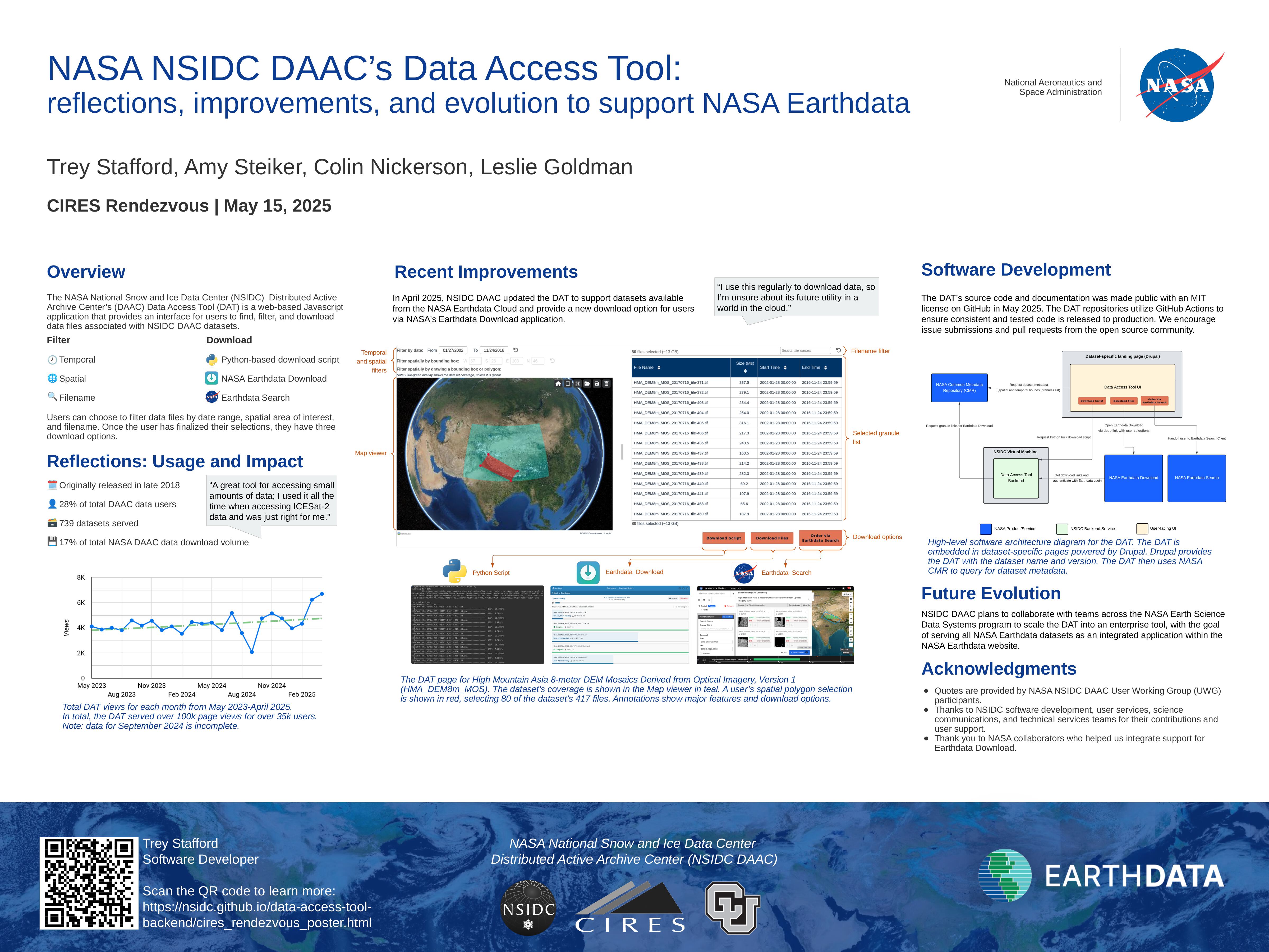
Abstract
The NASA NSIDC Distributed Active Archive Center (DAAC)’s Data Access Tool (DAT) is a web-based Javascript application that provides an interface for users to find, filter, and download data files associated with NSIDC DAAC datasets. Originally released in late 2018, The DAT currently serves 739 datasets, supporting 28% of total users and 17% of total data volume downloaded from the NSIDC DAAC. In April 2025, NSIDC DAAC updated the DAT to support datasets available from the NASA Earthdata Cloud and provide a new download option for users via NASA’s Earthdata Download application. In the future, NSIDC DAAC plans to collaborate with teams across the NASA Earth Science Data Systems program to scale the DAT into an enterprise tool, with the goal of serving all NASA Earthdata datasets as an integrated application within the NASA Earthdata website. This integration will make it easier for data users to search, discover and download the data they want without leaving the data landing page, improving the overall accessibility of NASA Earthdata.
This poster highlights the primary features of the DAT, reflects on usage over the years, and previews the DAT’s future as an enterprise NASA tool. The poster also provides information about the open source software that defines and powers the DAT, opening the possibility for collaboration with the open source community.
Poster
Try out the Data Access Tool
Below are some example links to dataset-specific instances of the Data Access Tool:
- ATLAS/ICESat-2 L2A Global Geolocated Photon Data, Version 6 (ATL03)
- Sea Ice Concentrations from Nimbus-7 SMMR and DMSP SSM/I-SSMIS Passive Microwave Data, Version 2 (NSIDC-0051)
- MODIS/Terra Snow Cover Daily L3 Global 500m SIN Grid, Version 61 (MOD10A1)
- High Mountain Asia 8-meter DEM Mosaics Derived from Optical Imagery, Version 1 (HMA_DEM8m_MOS)
- SMAP Enhanced L3 Radiometer Global and Polar Grid Daily 9 km EASE-Grid Soil Moisture, Version 6 (SPL3SMP_E)
Data Access Tool Software
The Data Access Tool is composed of three open source repositories in GitHub:
data-access-tool-ui: Web interface to support granule-level discovery and access of NASA Earthdata for a given data collection.
data-access-tool-backend: backend services that support the Python bulk download script and Earthdata Download.
data-access-tool-vm: NSIDC virtual machine configuration for deploying the backend service.